Recently, the reason for crazy rain+super temperature is found!
Author:Institute of Geological Earth Time:2022.06.24


"
(⊙_⊙)
One day a global humanistic and geography
WeChat public account: Earth Knowledge Bureau
NO.2242-Wind and Rain+High temperature
Author: Xiaoshe
School manuscript: Chaogan / Editor: Yangle Duo
On June 6, 2022, the Mangye species indicated that the midsummer arrived quietly. The seedlings meant that "the mango wheat is fast, and the rice can be planted." From June 7th to 9th, the college entrance examination means that the students who have read more than a dozen years have ushered in their "mango".
Planting seedlings and cutting wheat are busy, and the seedlings are burned on the night and pornography
(Figure: Tuwa Creative)

On June 21, as the sun reached the Northern Cancer, China located in the northern hemisphere entered the longest day during the year, and within one month after the summer solstice, Huaxia will enter Futian, and the temperature will continue to rise. , Welcome to the hottest season.
But at this time, standing at the bones of the midsummer at this time, looking back at the weather in the first half of June, this busy midsummer seemed a bit "deep water".
When "Dragon Boat Water" meets "Meiyu"
From May 21st to June 20th each year, it is the pre -flood season in South China. When a large number of precipitation occurred in the Dragon Boat Festival, it was commonly known as "Dragon Boat Water".
The cause of Dragon Boat Water is closely related to the South China Sea Summer Wind activities. The South China Sea Summer Merragons generally burst north in mid -May. Because it comes from the tropical ocean, it shows a light -density and a warm and humid gas group, which is unstable. Encountered the appropriate conditions, such as the compulsive vertical lifting movement of complex terrain such as Nanling and the local convergence of the sea and land wind, which can trigger the release of unstable energy.
Such a strong reduction of water is produced by a single warm and humid gas group, which is often called warm rainstorm.
When the monsoon meets the valley wind and sea and land winds
It will be forced to lift the trigger precipitation (signal at night)
(Reference: change in the wind of land and land in South China and its related precipitation)
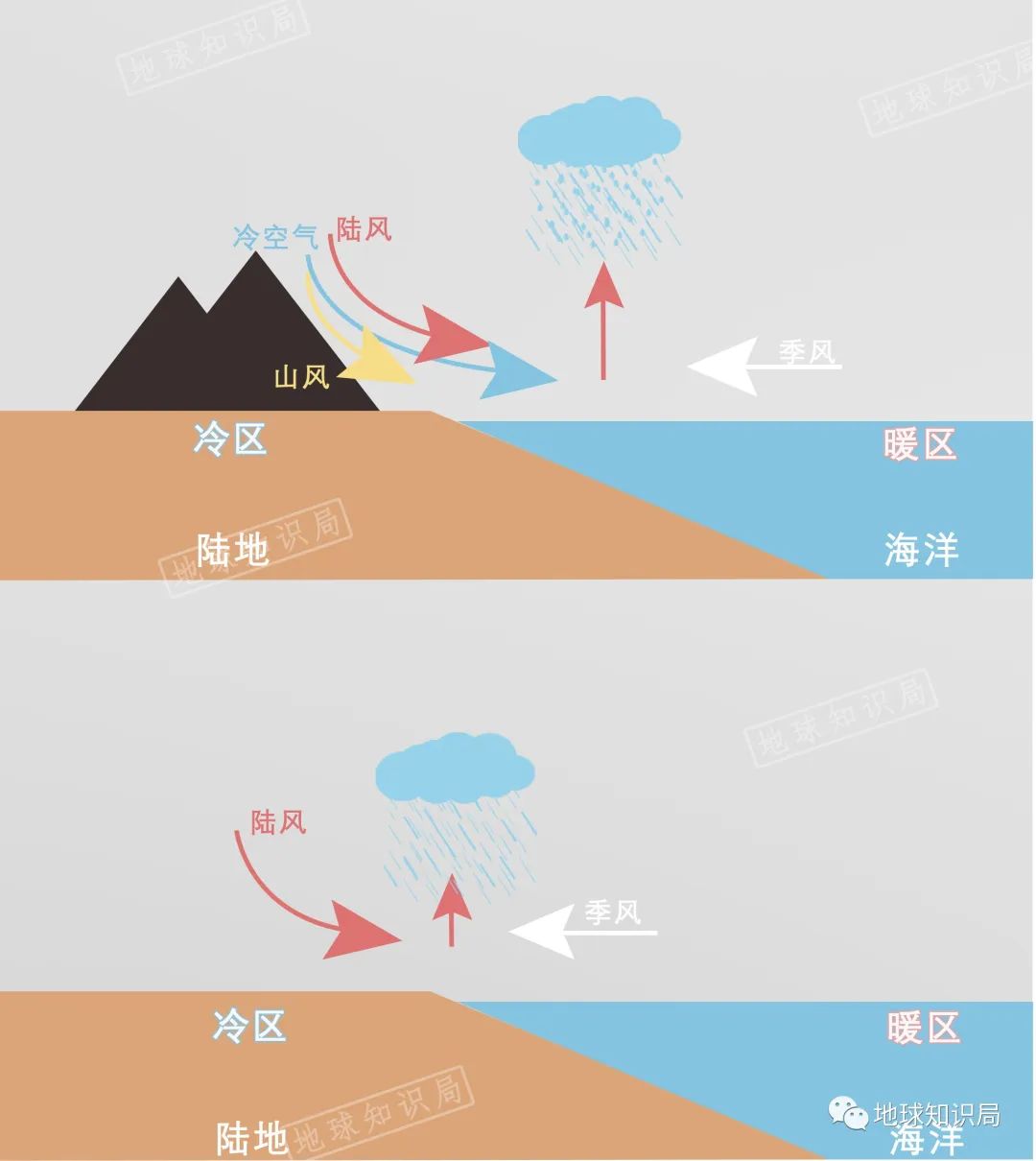
At the same time, from late May to early June, cold air activities can still go deep into South China, although most of them are quite weak. At the beginning of the summer wind, the cold and air flow was evenly matched in South China, and long -term convergence formed a frontal precipitation.
The warm and humid air from tropical ocean continues to transport to South China
Hit the north with the cold air north, the hot and cold confrontation, and the rainstorm strikes

Under the joint influence of monsoon precipitation and frontal precipitation, a large and concentrated strong water reduction weather also appeared in South China from late May to mid -June, that is, "Dragon Boat Water". With the advent of the "Dragon Boat Water", the water level of the river rose rapidly, providing good venue conditions for the Dragon Boat.
The dragon is moving, and the river shadow shadow joint
In

This year, the Summer Summer Wind of the South China Sea broke out in mid -May, which is slightly earlier than usual, and its intensity is close to usual.
Usually within two weeks after the outbreak of the South China Sea summer wind, the monsoon flowing the southwest warm wet water vapor to enter the East Asia from the Tropical Indian Ocean and the South China Sea. Since then Enter the main flood season.
Every year in June and July, when the plum is mature
The rain and rain in the middle and lower reaches of the Yangtze River are constantly rainy
(Figure: Tuwa Creative)
Since the spring of this spring, due to the influence of the East Middle East Pacific La Nina incident, the Western Pacific Deputy High School and our country are north, indicating that the time of the South my country Sea Summer Explosion, the rainy season in the Southwest, and the Jianghuai Meimei rain start time is expected to be too early.
According to previous forecasts, from late May to early June, the rain belt should be moved to the Jianghuai Basin earlier, and most of the precipitation intensity in South China will be significantly weakened. However, it was not expected that although the Jiangnan and the Yangtze River in my country had entered the plum on May 29, it was 11 days and 16 days earlier than usual. But after entering the plum, the rain in Fujian, Guangdong, Guangxi and other places did not weaken, but it seemed to be "open".
Xiaoyu shouted heavy rain, heavy rain shouted to heavy rain, endless
The average precipitation of the three provinces in Fujian, Guangdong, and Guangxi reached 621 mm, which was the largest in history since 1961. Guangdong and Fujian, which have been dry for many years, are experiencing the most longest water and the largest "dragon boat water" for more than half a century.
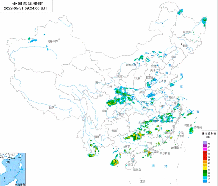
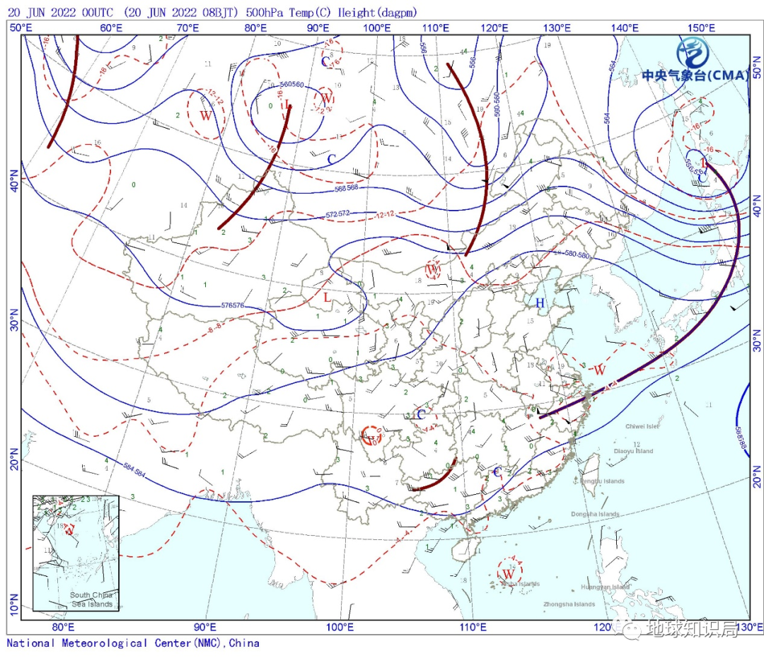
5.500HPa on May 31st
As far as Guangdong is concerned, the days when the dragon boat is not raining can be counted ...
Affected by continuous rainfall, heavy rain and flood disasters occurred in many places in South China and Jiangnan, and many small and medium -sized rivers in the Pearl River Basin Super Police. Many netizens directly called "Guangdong's sky leaked" and "what they have forgotten the sun."
Dark rain and heavy rain all the time
Shanghai, which enters Mei, does not have the feeling of "mold" in the rainy season. Because the main rain belt is located in the far southern region, the precipitation has decreased significantly compared with previous years, and it is partially drought than in previous years. There is no feeling of Huang Meitian.
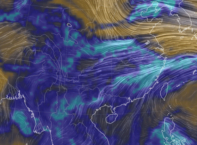
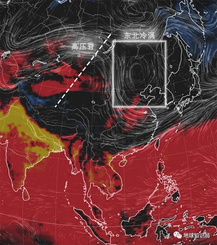
We need to look away from the West Pacific and Rain Belt in the south, and look at the north
The wind farm under 500HPA on June 12th
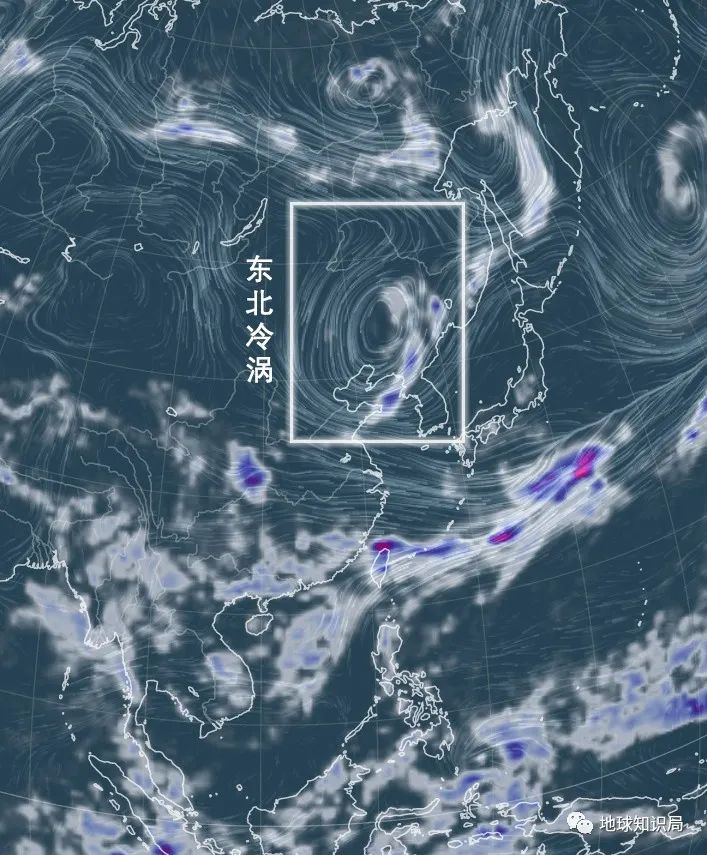
You can see two obvious weather systems in the north
Northeast cold vortex and warm high pressure ridge
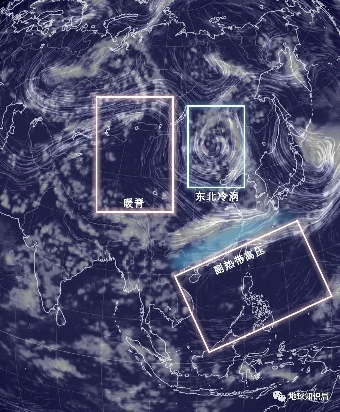
The friends of Beijing -Tianjin -Hebei should have a deep understanding recently. Some time ago, I always came with an umbrella. Once I forgot, they would be easily forced to hide. The reason behind this is that there is a strong northeast cold vortex, which constantly stimulates strong thunderstorms and even hail clouds to enter Beijing -Tianjin -Hebei, causing strong convective weather.
The reason for the heavy rain in South China is that the Northeast cold vortex activity in the north since early June, suppressing the high and weak sub -high due to Lanna, which eventually caused the main rain in the middle and lower reaches of the Yangtze River. And gradually returned to the south of Nanling.
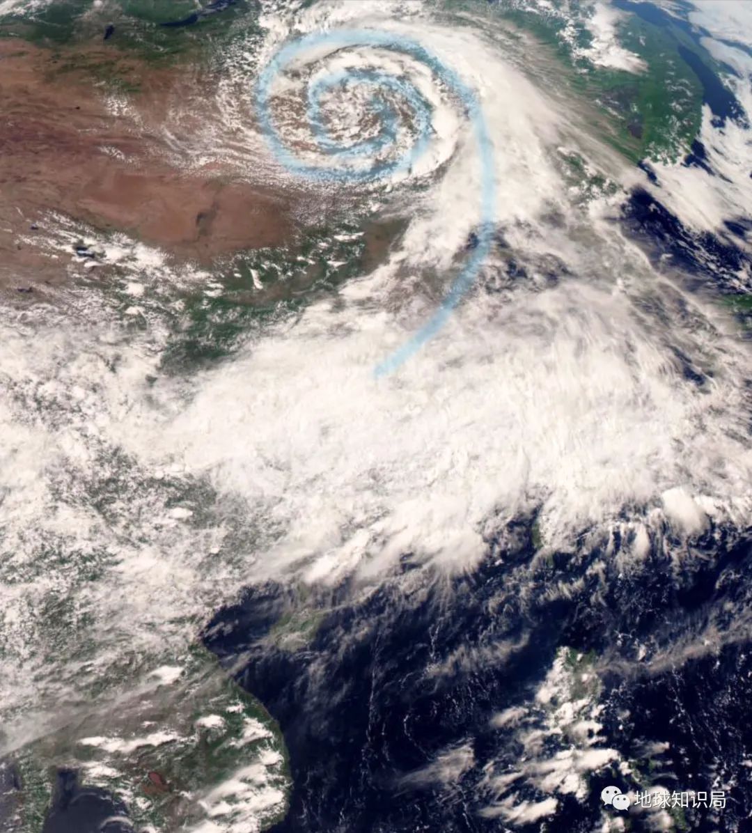
The characteristics of the funny cloud system of cold vortex on the satellite map on June 12 are obvious
And suppress the secondary high pressure on the southeast coast
(Figure: FY-4A satellite cloud map)
So what exactly is the cold vortex in Northeast China? Why is there such a great power?
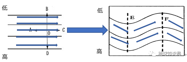
We all know that from April to June, the northern side of my country is mainly located on the north side of the deputy high, and it is controlled by the west wind band in the middle latitude. However, the western wind band is not always straight at the high altitude, and there will be disturbances south or north. The warm and high pressure that is prominent north is a high -pressure ridge, and the low pressure extended to the south is a low -pressure groove.
500HPA's high line and ground turning wind showing diagram
(The picture on the left is a straight west wind belt, and the picture on the right is a groove ridge formed after disturbing)
However, during the development and evolution of the groove ridge in the west wind band, when the groove is continuously deepened, the connection between the cold and cold air and the northern cold air will be cut off by the warm air. Form an isolated closed cold low pressure center on the south of the groove. Called cutting low pressure, often manifested as a cyclone vortex. The cold vortex of the Northeast is a low pressure that has a certain intensity in the northeast of my country, which can maintain it for more than 3 days and has deep cold air.
Northeast cold vortex will appear all year round. May to August is the most frequent event, especially the most active around June. This year's cold vortex is particularly active. As of June 14 this year, 14 Northeast Cold Vortex has appeared. Among them, two Northeast cold vortexes have appeared since June 6.
The wind farm under 500HPA on May 25 can clearly see the cold vortex of the Northeast
As a result, many regions in the Northeast in May at the end of May have cool down sharply
Some areas are also accompanied by shower and thunder showers
However, due to the high temperature of the ground in summer, the temperature of the ground is high and the water vapor is more. If it encounters a high -altitude and cold air, it forms a unstable structure of cold and down warm, which is very easy to stimulate the local -based convection weather. For example, from June 11th to 12th, the cold vortex in Northeast China caused strong convective weather such as heavy rain and hail in many places in North China. In Beijing, there were also weather such as thunderstorms and winds.
At 10:20 pm on June 12, hail picked in the community
(Figure: Yangle Duo)
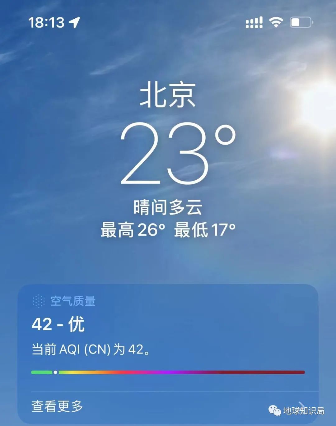
At the same time as the increase in precipitation in the Northeast Cold Vortex, the temperature decreased significantly with the temperature. Last week, in the northeast and North China region, it was obvious that this year's summer was not only hot, but also full of cool morning and evening.

At 18:13 on June 13th, the temperature in Beijing was 23 degrees
This temperature is pleasant and cool (picture: Yangle Duo)
Although the main body of the cold vortex in the Northeast is in the northeast, its sphere of influence is not limited to this. The continuous Northeast cold vortex will "throw" the cold air, and the summer wind and warm in the front side of the South China deputy high. The front precipitation eventually created this protracted and long -lasting "dragon boat water".
But don't forget that the cutting low pressure with the northeast cold vortex is often generated by high pressure spine, so the back side of the cold vortex in the northeast corresponds to the warm and high pressure in the northwestern region of China. Under the control of heating and high pressure, 46.1 degrees of high temperature appeared in the Xinjiang Turpan Basin on June 14, which was a new high in the country since this year. Strong light heating group carried by heating and superimposed with heating spine
As a result, the top ten in the national temperature list are in Xinjiang
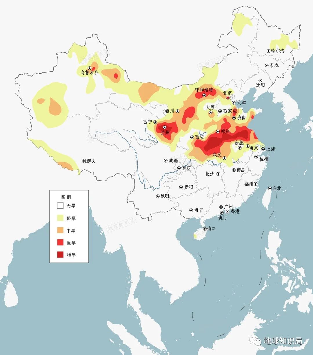
In early June of this year, Henan and other places have encountered high temperature and rainy weather. Although the precipitation from the cold vortex after that has later relieved the drought in some areas. However, on June 15-16, high temperatures above 40 degrees spread from Xinjiang and Inner Mongolia, and netizens directly called "Henan has become hot to South."
At this time, autumn corn in many areas in Henan just planted
The surface temperature is too high or should not be in crop growth (6.16 drought monitoring map)
What will
As the cold vortex moved east of the Northeast earlier this month, the influence gradually withdrew from the East Asia. On the 20th, it had basically moved to Ohitzk. Accompanied by the high -pressure ridge and the entire west wind disturbance system, it has gradually moved eastward, and it has basically moved to Beijing, Tianjin and Hebei.
Move the high -pressure ridge to Beijing early on June 20th
(Figure: Central Meteorological Observatory)
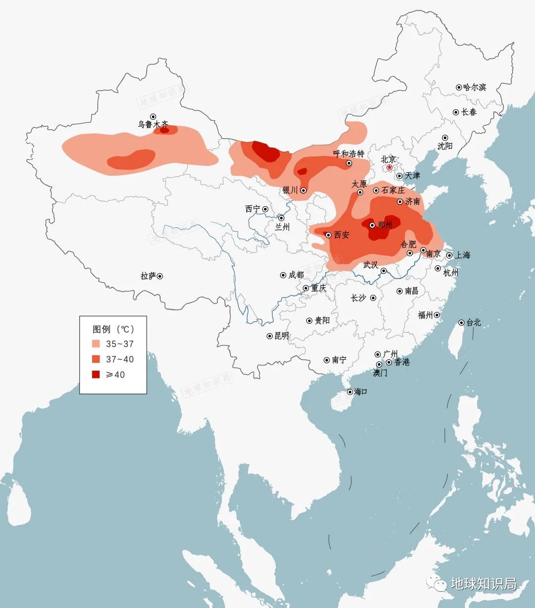
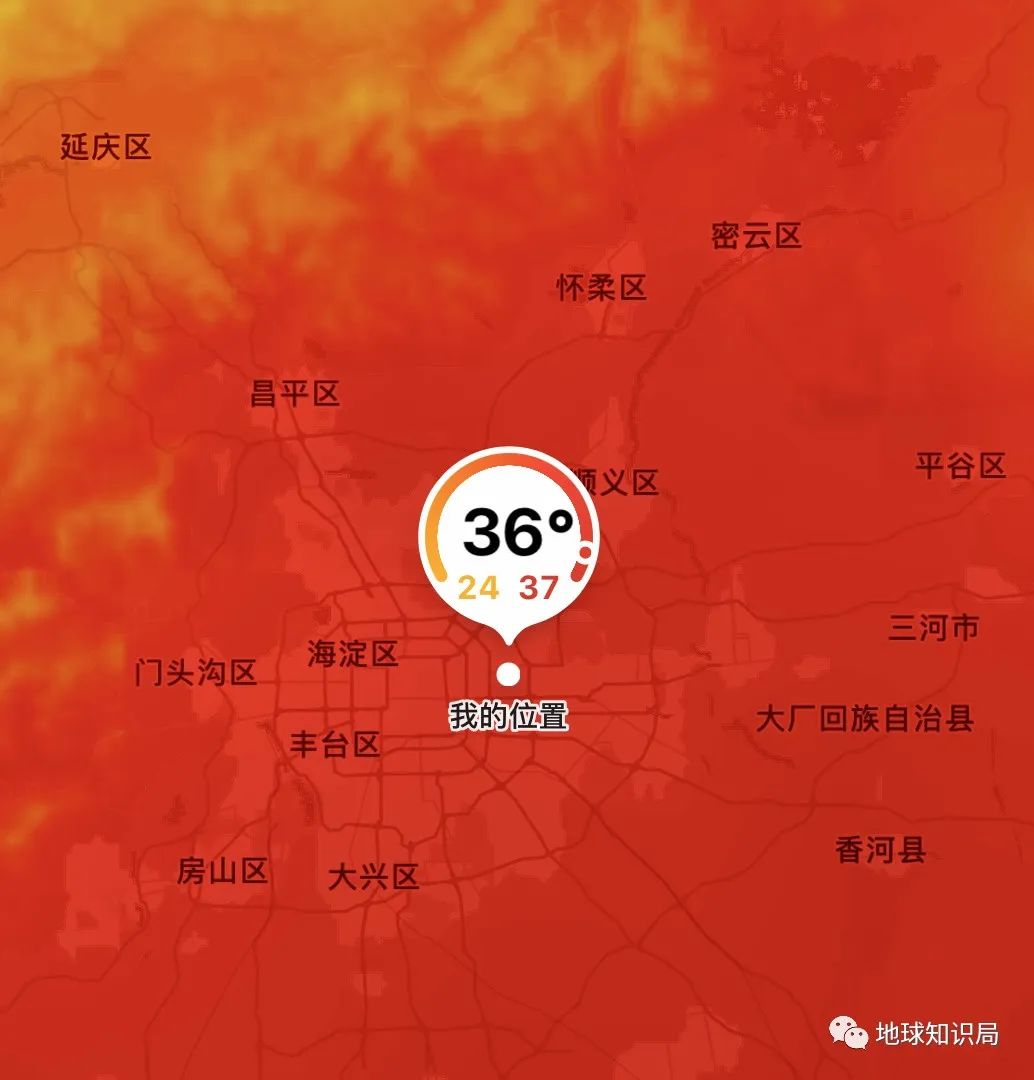
Accompanied by warm and high pressure that continues eastward and south, the heat waves spread from west to east, from north to south. Shanxi, Henan, Shandong, and Jiangsu and Anhui, Guanzhong Basin and other areas appear. The local area can reach about 40 ° C. The high temperature center in central Henan, Zhengzhou, Luohe and other places will last 39-40 degrees of high temperature weather a week. On the 20-21 days, the warm ridge controls North China. The highest temperature in Beijing can reach 35-36 ° C. The air humidity is large and the body feels sullen.
June 17th-20:00 on the national high temperature settlement area forecast map
In this high -temperature championship battle, Henan won without suspense ...
Today's Beijing, hot heat, hot heat, hot heat, hot heat
It is precisely because of the large disturbances of the northern glow ridge and the weakness of the auxiliary height that lasted for a period of time, and the heavy water drop process in Jiangnan and other places in South China also maintained a long time. However, as the cold vortex weakened in the Northeast, the hindered subtropical high pressure began to lift north.
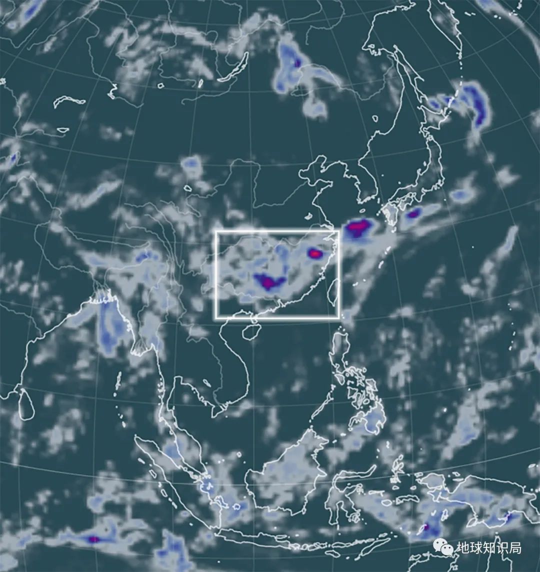
From the 20th, although there are still heavy rain in northern Guangdong, the real main rain belt has come north to Hunan, Jiangxi and Zhejiang. Due to the significant changes at this time, it is likely to face rapid changes in extreme weather such as high temperature, rainstorm, and strong convection. The formation of tornado; the breaking record of the heavy rain caused the Pearl River Basin to cause super floods.
11:3 hours on June 20 (the deeper the color, the higher the precipitation, the higher the amount of precipitation)
Shaoguan, Guangdong, Wuyuan, Jiangxi, Fujian Songxi and other southern areas
Disaster flood disasters have occurred
However, the good news is that starting on June 22, the deputy Gaogao North and west will be controlled quickly. The former flood season in South China will end, and the heavy rainfall will stop. However, the southeast coastal area will usher in the sunny and humid "sauna days" under the influence of the deputy high -sinking air.
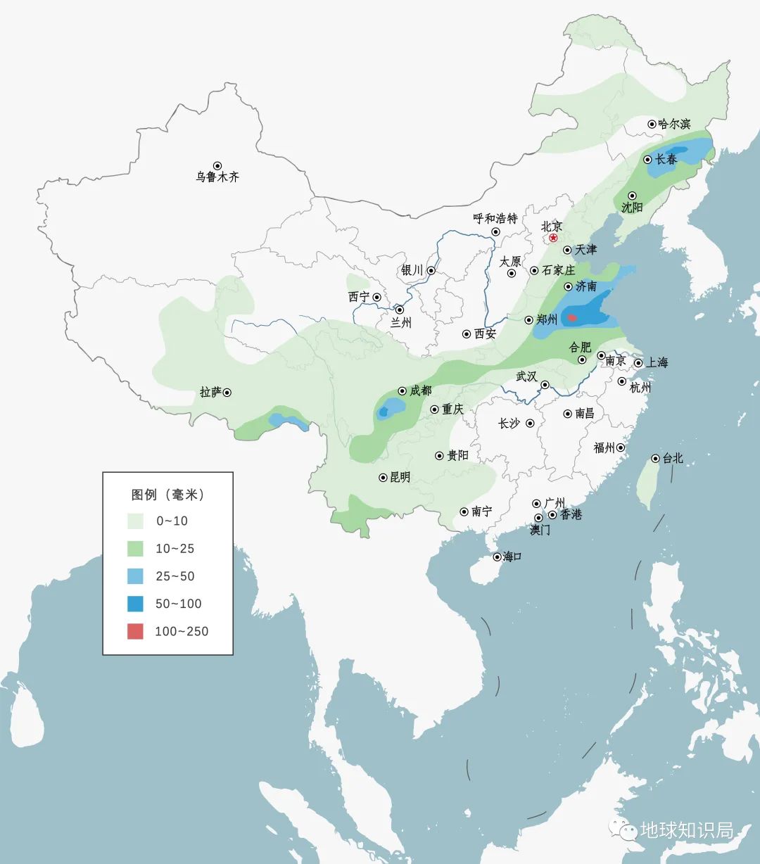
The main rain belt will quickly move north to Jianghuai and even Huanghuai. Precipitation will occur in Henan and Shandong around the 23rd, which will relieve the local drought. But this also means that this year's Meimei is extremely typical, and there may be a situation where hasty starts and the end of the grass.
20:00 on June 22nd to 20:00 on the national precipitation forecast map
The far -reaching reason also needs to look at the distant tropical Pacific: La Nina, who should be attenuated quickly after reaching its peak in winter, is far from weakening as expected. The development of the development corresponds to the Sitai high, and it should continue to be weak north, but recently, due to the strong northeast cold vortex, it has been pressed south of South China for a long time.
The temperature distance of the global sea watch from May-June, you can see the obvious Lamanina status in the tropical Pacific Ocean
Therefore, this year's midsummer, the auxiliary high may jump north quickly, resulting in abnormal rain and drought and floods in the north. According to the predictions of the National Climate Center before, it is expected that the precipitation in northern China this summer should be more than that, and there may be more heavy flood conditions. In the next few months, the north should still pay attention to prevent possible waterlogging risks.
Reference materials:

[1] China Meteorological Bureau: South China Sea Summer Midstream Wind in May 3rd, slightly earlier than usual 2022.05.11
http://www.cma.gov.cn/2011xwzx/2011xqxxw/2011xqxyw/20220220511_417988.html
[2] China Meteorological Bureau: The climate of my country's main flood season is generally to the general regional and phased drought and flood disasters.
http://www.cma.gov.cn/2011xwzx/2011xqxxw/2011xqxyw/202206/t20220602_4880248.html
[3] Research Progress of the Research Progress in the Research Progress of Rainstorm in the warmth of China in the warmth of China in the warm rain disaster, 2019,38 (05): 483-493.
[4]Xingchao Chen and Fuqing Zhang and Kun Zhao. Diurnal Variations of the Land-Sea Breeze and Its Related Precipitation over South China[J]. Journal of the Atmospheric Sciences, 2016, 73(12): 4793-4815.[5 ] China Meteorological Administration: The middle and lower reaches of the Yangtze River in the south of our country have entered May 29th, which is significantly significantly earlier than usual 2022.06.02
http://www.cma.gov.cn/2011xwzx/2011xqxxw/2011xqxyw/202206/t20220602_4880537.html
[6] Central Meteorological Observatory: The average rainfall in the Fujian and Guangdong region since May is the third in the same period of history in the same period in the next week.
http://www.cma.gov.cn/2011xwzx/2011xqxxw/2011xzytq/202206/t20220614_4903828.html
[7] China Meteorological Bureau: Summer is like cool autumn? Cold in Northeast Cold Vortex active 2022.06.14
http://www.cma.gov.cn/2011xwzx/2011xqxxw/2011xqxyw/20220614_4904354.html
[8] China Meteorological Administration: There will still be a strong precipitation process in Jiangnan and other places in South China, and there will be continuous high temperature weather in North China and other places. t20220616_4907327.html
[9] China Meteorological Administration: Jiangnan South China and other places have strong precipitation in the northeast of Inner Mongolia. There are high -temperature weather in Huanghuai and other places in the northeast of Inner Mongolia.
2022.06.20
http://www.cma.gov.cn/2011xwzx/2011xqxxw/2011xzytq/202206/t20220620_4916350.html
*The content of this article is provided for the author, which does not represent the position of the Earth Investment Bureau
Cover: shutterstock
- END -
up to date!The Xiamen Health Commission issued important notice!Related influenza

To further strengthen influenza prevention and control workThe Xiamen Health Commi...
Heroes, go home!

Original title: Hero, go home!The burial ceremony of Liu Zejun's martyr's ashes wa...