Li Chao et al. -Nature: Zhu Rong's inspection radar first revealed the superficial structure of Mars Utopia Plain
Author:Institute of Geological Earth Time:2022.09.27


Summary:
The detailed Mars underground structure and physical information are the key basis for studying the evolution of Mars geology and its livable environment, and one of the important contents of Mars detection. On May 15, 2021, the Zhurong Mars car carried by my country "Tianwen No. 1" successfully landed in the south of the utopian plains. Based on the low -frequency radar data collected for about four months of Zhu Rong Mars, through fine analysis and imaging, for the first time, the largest impact basin in the north of Mars -the high precision underground (<80 meters) structure of about 1171 meters in the south of the utopian plains (<80 meters) structure The hierarchical images were found to have about 10-30 meters and 30-80 meters depth under the weatization layer of the fire watch in the area. There are two sets of sedimentary layers that become thinner upward. Further use the dielectric constant to extract stratigraphy information, revealing that the southern part of the utopian plains has experienced multiple phase of fire watch reconstruction events since the evening of the West (3.5-32 billion years). ) The geological process related to the development of water may still be developed; no evidence of liquid water is found in the shallow 80 meters of the area today, but the possibility of salt ice is not ruled out. This study provides an important observation foundation for in -depth understanding of Mars geological evolution, environment and climate change.
On May 15, 2021, the Zhu Rong Mars car carried by Tianwen No. 1 in my country successfully landed in the south of the Utopia Plain (Figure 1A, Figure 1B). The Utopia Plain is Mars's largest impact basin. It may be a huge ancient ocean, indicating that there may be a livable environment in the early days of Mars. The Utopia Plains are widely covered by the Vastitas Borealis Formation (VBF). The strata may represent the deposition or remaining sedimentary substances formed by the deposition or ancient ocean -related sedimentation of floods. In addition, the utopian plains have many typical landforms (Figure 1c), such as giant polygon, concave cone, barriers, etc., all indicate that Mars has excessive water/ice in the past. However, it is still unknown whether there is still water/ice in the area underground in the area, which limits our understanding of Mars's water body evolution.
In 1976, the U.S. Pirate 2 detector landed in the northern part of the Utopia and implemented the landing detection for the first time, but failed to detect the underground structure. Although the Mars high -altitude rail radar can detect the superficial structure of Mars worldwide, its resolution is low, especially for the lightness of the superficial 100 meters. The second surface detection radar carried by my country "Tianwen No. 1" can effectively imagine the shallow structure of the underground underground in the inspection area and deepen our understanding of key scientific issues such as the evolution of the utopian plain and the distribution of groundwater/ice distribution.
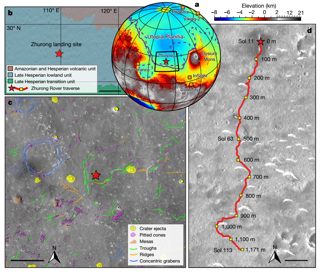
Figure 1 Wishes the geological geological map of the landing area. (A) Zhu Rong, Phoenix, Insight, Curiosity, Perseverance, and Pirates Lowing Point and Pirates Location; Zhu Rong's terrain and facade diagram near the landing point is 15 kilometers;
I wish Rong Rong Mars car secondary surface detection radar
Zhu Rong Martian car is equipped with the Rover Penetration Radar (Roper) is the first inspector radar detection carried out in the Utopia Plain in the world. So far, human beings have conducted four inspection radar detection on the places outside the earth. Among them, my country Chang'e 3 and Chang'e IV for the first time have achieved fine detection on the front and back of the moon. The American Perseverance and my country Zhu Rong inspector opened a new era of Mars radar inspection and detection in 2021. The exploration area of the perseverance is the edge of the Jezero impact pit, which is limited to the main frequency of the radar (150-1200 MHz), and its actual maximum detection depth is only 15 meters. Compared with the perseverance radar, the frequency of the Zhu Rong high-frequency radar is higher (450-2150 MHz), and the frequency of low-frequency radar is lower (15-95 MHz), which makes the high-frequency radar shallow about 0-5 meters depth depth of about 0-5 meters depth. The table target can be seen more "meticulous", low -frequency radar is more "in -depth" for underground targets, and the actual maximum detection depth is 80 meters.
I wish the underground layered structure and geological interpretation of Mars car inspection path
The Star Structure Research Team of the Institute of Geology and Earth Physics of the Chinese Academy of Sciences, the research personnel such as the National Space Science Center and Peking University, and other scientific researchers, the low -frequency radar data collected by Zhu Rong Mars in the first 113 -meter -long collection of Mars is in -depth. Analysis, obtained a high -precision structured image and strata physical information of 80 meters (Figure 2).
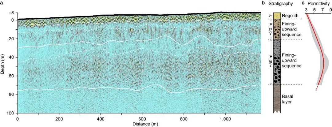
Figure 2 Low -frequency radar data imaging results and interpretation. (A) Low -frequency radar section; (b) rock -based strata; (C) Average dielectric constant changes with depth. The white solid line is a strata -level division, and the dotted line is the general division of the changes in the inter -layer reflection mode
According to the characteristics of the reflex mode and estimated dielectric constant, the underground structure can be divided into four layers (Figure 2). The thickness of the first layer is less than 10 meters, and the average dielectric constant is between 3-4. The depth of the second layer is about 10-30 meters. The reflection energy in this layer gradually increases with the depth, but the clear and continuous reflection interface has not occurred. The average dielectric constant is 4-6. Numerical simulation indicates that these reflex characteristics represent that the layer contains more stones, and its particle size gradually increases with the depth. The depth of the third layer is about 30-80 meters, which is similar to the second layer. This layer also has the characteristics of changes in the mode of reflection with the depth of depth from the weak enhancement. This shows that the stone particle size in the third layer is larger (can be reached) and the distribution is more messy. In addition, the clear third layer interface is observed, which is because there is no dielectric constant comparison of the medium material change at the bottom of the layer, or the depth of the radar reflection energy is very weak at the depth of about 80 meters, reaching the detection limit to the detection limit Essence Combining radar images with the depth of excavation and age constraints in the landform of the landing area and the impact pit to get the following understanding:
(1) The upper layer of the depth of less than 10 meters is the fire layer;
(2) The second layer sequence of depth at 10-30 meters may be the result of the renovation event of the Amazon Firewatch in the landing area. The short -term flood, long -term weathering, or repeated meteorite impact may form this layer of sedimentary layer (Figure 3B) in this layer.
(3) The third layer sequence of depth in the depth of 30-80 meters may reflect the older and larger fire watch reconstruction events in the landing area. Based on the annual results of the impact pit, it is estimated that the transformation event may occur from the Western Ji of the West 3.5-32 billion years ago to the Amazon, which may be related to the large flood activities in the southern part of the Utopia Plain (Figure 3A).
In addition to layered features, another important structural characteristics of the radar section are smooth transitions between layers (Figure 2A). This shows that within the depth of the depth of Zhu Rong's landing area, the primitive basalt of the primitive basalt may be missing or too thin from the primitive basalt of the Erosion volcano or some late volcanic effects. Essence Otherwise, because there is a significant difference in the constant of Xuanwu and sedimentary rock dielectric, a strong reflection interface will appear on the radar section. This explanation also receives support from the estimation of the dielectric constant (Figure 2C). Lutch areas ~ 3-7 The frequent value of the dielectric is significantly lower than the superfliming dielectric constant (about 9) of the Amazon Perision volcanic unit (about 9), but the Mars Advanced Radar for Subsurface Andosphere sounding, Marsis) estimates the frequency of dielectric norms (about 5) in the similar in -depth range of VBF.
Figure 3 Drawing model diagram of the southern fire watch of the utopian plains. (A) In the evening of the Western Ji to the early Amazon, a large flood incident occurred. As the flood faded, the sequence of fragile sedimentation of the upward became thinner, the ratio was 20 meters; The impact function transformed the fire watch, forming a sedimentary sequence that changes upward from the stack of small rocks; The table is mainly based on the process of winding and erosion
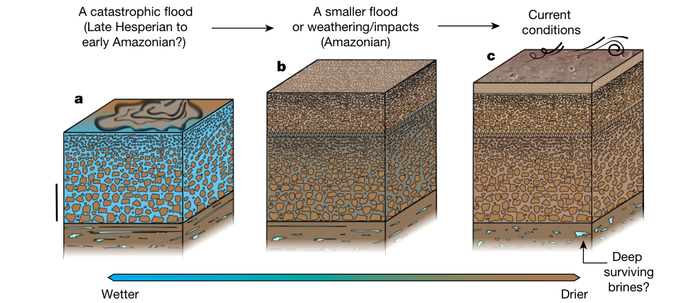
There is no liquid water within 80 meters of the fire watch, but there may be salt ice
One of the main goals of Zhu Rong Mars' second surface detection radar is to detect whether there is groundwater/ice in the southern part of the Utopia Plain today. If there is a water -rich layer, the radar signal will be strongly attenuated to reduce the detection depth. The results of low-frequency lightning reaching the results show that the signal strength in the depth of 0-80 meters is stable and there is no water richer. In addition, this study is low (not more than 9), which is not constrained by the discrimination constraint. Different from the high -agent constant (greater than 15), which is different from the aquatic substance, the possibility of a water layer below the inspection path is excluded. The results of thermal simulation also further showed that liquid water, sulfate or carbonate brine is difficult to stabilize on the shallow 100 meters of the Zhurong landing area. However, because the dielectric constant (2.5-8) of sulfate or carbonate ice ice is equivalent to the rock-based material, the possibility of salt ice in the shallow layer cannot be ruled out.
In summary, the research is based on the low -frequency radar data of Mars car in my country. Through fine analysis and imaging, it has obtained a shallow (<80 -meter) structure and physical information for the first time through fine analysis and imaging. It provides an important basis for in -depth understanding of Mars geological evolution, environment and climate change.
Research results published in Nature (Li Chao#, Zheng Yikang#, Wang Xin#, Zhang Jinhai#, Wang Yibo, Zhang Lei, Zhao Pan, Liu Yike, Liu Yang, Zhao Jinlai, Sun Weijia, Sun Wei,Liu Xiaofeng, Jia Bojun, Li Juan, Lan Haiqiang, French philosophy, Pan Yongxin, Wu Fuyuan. Layered Subsurface in Utopia Basin of Mars Revealed by Zhurong Radar [J]. Nature, 2022. DOI: 10.1038/S41586-05147-5-5-5To.The study was jointly funded by the key deployment projects of the Institute of Geology and Earth Physics (IGGCAS-2012102), the key deployment projects of the Chinese Academy of Sciences (ZDBS-SSW-TLC001), and the National Natural Science Foundation of China (42288201 and 41941002).Beautiful editor: Han Yatong
School pair: Wanpeng

- END -
The finals of the Same Studio Youzhong Youzhong Youzhong Youzhong Guo Zhoukou City Innovation and Entrepreneurship Contest staged a peak duel

Zhoukou Daily · Zhou Dao Client Seeing Surverance Reporter Tian Yananwen/PictureO...
"Douyin 818 Discovery Good Things Festival" is online, and interest e -commerce to help the national tide sales of good things

During the event, the platform specifically launched the Encouragement area, focus...