Yinyun is cool and pleasant 丨 taste autumn
Author:Sichuan Provincial Meteorologi Time:2022.08.31

31
Wednesday
August 2022
The fifth day of the lunar calendar

Retrospective
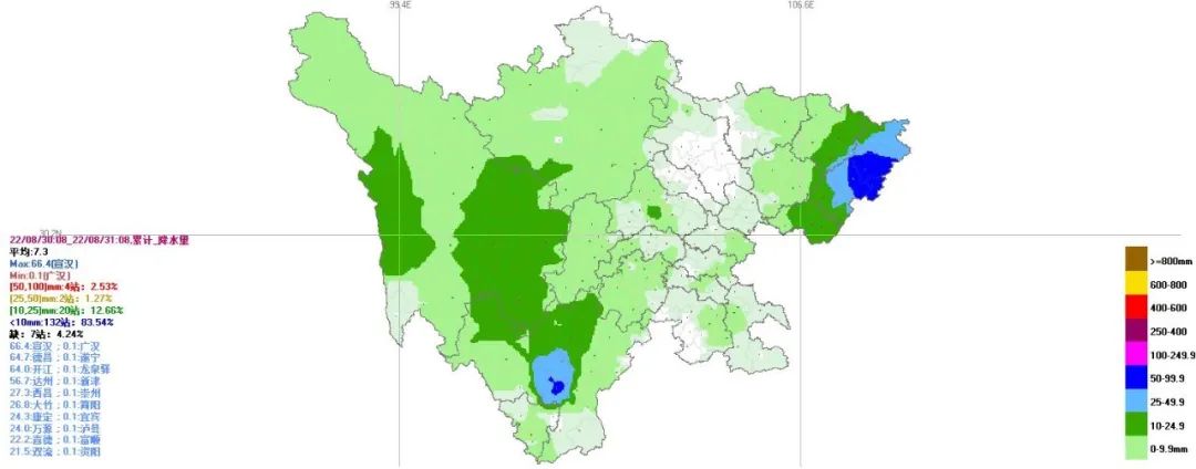
(Cumulative rainfall on the 30th to 08:00 on the 30th)
Yesterday from 08:00 until today at 08:00, Dazhou, Pakistan, and Guang'an Central in the northeast of the basin to heavy rain, some places heavy rain, the rest of the basin of the basin, the heavy rain, the rain of the plateau, the heavy rain in some places, and the heavy rain in the west of the West. Essence The lowest temperature in the basin this morning was 17 to 20 degrees. Yesterday, the highest temperature was 20 to 22 degrees in the northeast, and the remaining places were 24 to 26 degrees. Compared with the early temperature, the temperature returned to normal.
At 14:00, the temperature is active

This morning, the sky was covered, and the rainfall fell in some places, which was basically the same as yesterday. In the afternoon, the situation in the sky is similar to the morning, there are scattered shower at night, and there are medium rain in some places; friends with rain utensils ~~
National Entrusted Autumn Process Map

End of the high temperature season!
The latest#最 最 最 最 最#
See where the footsteps of autumn are
With the end of the high temperature season, seasonal seasons are quietly occurring, and the footsteps of autumn are getting closer and closer. At present, where have you joined the autumn group chat? Let's launch the latest national autumn process map to see what season your home is.
Weather forecast in the next 24 hours
Tonight: Guangyuan, Mianyang, Meishan, Leshan, Yishan, Ziyang, Neijiang, Zigong, Yibin, and Luzhou 9 cities are cloudy and cloudy. There are scattered showers in the cities in the remaining cities in the basin; There are medium rain in the middle; the west and southern parts of the west area are small to the middle of the rain, the local heavy rain, the remaining places are cloudy, there are scattered shower or thunderstorms.
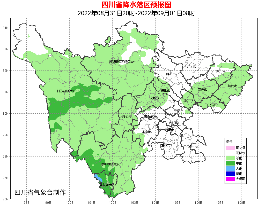
Tomorrow day: Cloudy days in the cities in the basin, among which Mianyang, Deyang, Chengdu, Ya'an, Leshan, Bazhong, Nanchong, Dazhou, Guang'an, Suining, and Ziyang 11 have scattered shower; Among them, there is a middle rain in the northern part of Ganzi Prefecture; the clouds in the west area are cloudy or decentralized or thunderstorms.
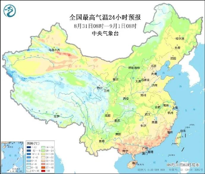
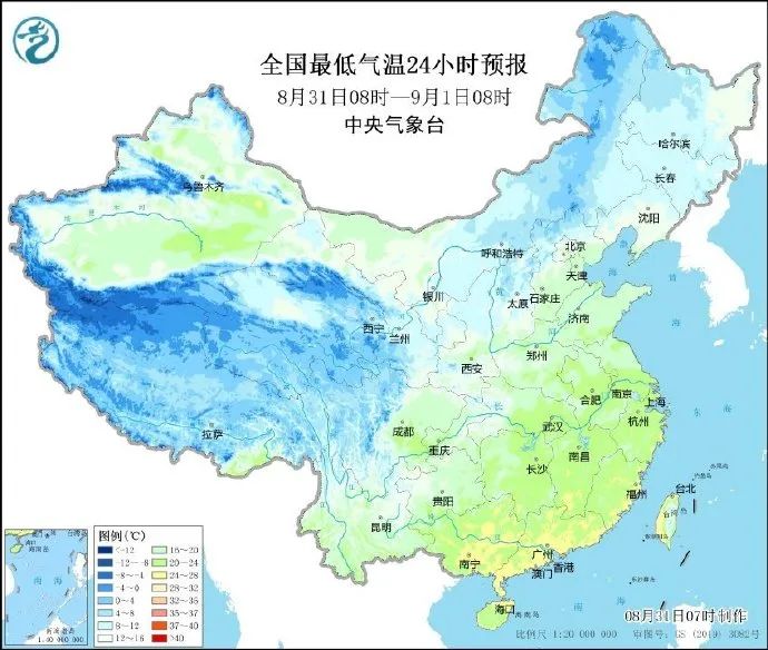
Within 24 hours, the lowest temperature in the basin: 17 ~ 19 ° C; the highest temperature: 20 ~ 22 ° C in the northeast, and the rest of the place 24 ~ 26 ° C.
Main cities 3 days forecast

Weather trend
According to@Meteorological Observatory
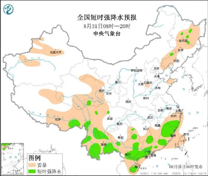
On August 31, some areas in western Sichuan Plateau, Yunnan, southern South China and other areas have middle to heavy rains, heavy rainstorms, and are accompanied by strong convective weather such as short -term heavy precipitation and thunderstorms.
On September 2-4, there will be small rain in eastern Qinghai, southern Gansu, Sichuan, Chongqing, Guizhou, and Yunnan, and the local area will be as heavy as heavy rain.
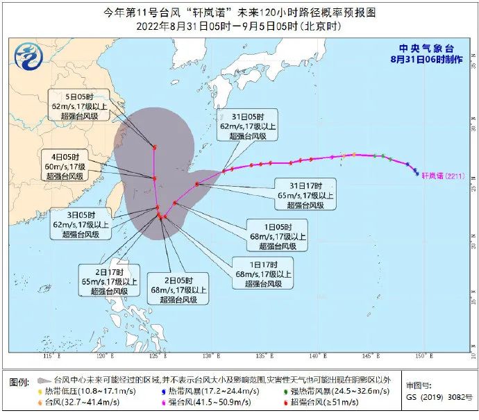
Typhoon No. 11 this year's "Xuan Lannuo" (Super Typhoon Grade) Center today (31st) at 5 o'clock in the morning in Naha, Okinawa Prefecture, Japan, on the northwest Pacific Ocean, which is about 340 kilometers east of Naha, Okinawa Prefecture, Japan, the largest near the center The wind is above 17 or above (62 meters/s), the lowest air pressure in the center is 915 hundred Pache, the seventh -level wind ring radius is 220 ~ 230 kilometers, the 10 -level wind ring radius is 70 kilometers, and the twelve -level wind ring radius is 40 kilometers.
It is expected that "Xuan Lannuo" will move to the southwest to the southwest at a speed of about 30 kilometers per hour. From September 1st to 2nd, it will stagnate or spin at the east of the Ryukyu Islands, and then move to the north to move north. On the 3rd day, he moved into the sea on the southeast of the East China Sea. In the next 4 to 5 days, "Xuan Lannuo" will maintain the strength of the super typhoon level, with a maximum strength of up to 17 or above (62 ~ 70 meters/s).
Affected by it, during the day from the 31st to the night of September 2, the waters of the southern Yellow Sea, the majority of the East China Sea, the Taiwan Strait, the Toyo of Taiwan, and the buses will have 6 ~ 8 to 10 gusts. Among them, the wind power of the southeast of the East China Sea and the east of the east side of Taiwan can reach 9-12 and the gust of gusts 13-14.
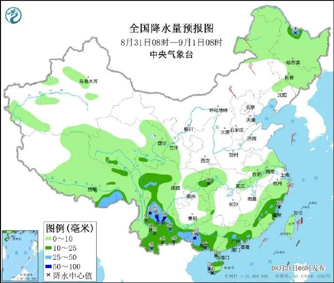
From 08:00 on August 31 to 008 on September 1st, northern Heilongjiang, southeast of Tibet, western Sichuan Plateau, northern Chongqing, central and eastern Yunnan, central and western Guangxi, central and southwestern parts, central Zhejiang, Hainan Island, Hainan Island, Hainan Island There are mid -to -heavy rain in parts of the north and southwestern parts. Among them, there are heavy rains (50-70 mm) in southern Sichuan, northwestern Yunnan and the central and eastern parts of Guangxi, and western Hainan Island. There are 4 to 6 winds in the northeast and central parts of Inner Mongolia (see Figure 2). The northeast winds of level 6 to 7 and gusts of 8-9 levels of the east and southern seas of the East China Sea will turn northwind.
Fire Memorandum
Look at it! Remember these points in early autumn!
The high temperature is about to end, and the autumn has "arrived one after another." As the autumn wind gets cold, the strings of fire protection must be tightened, the sky is dry, and the fire is easy to cause. In addition to paying attention to adding clothing appropriately, pay attention to the weather changes at all times.
In the early autumn, the following points should be remembered. Poke the picture ~


Click to read the original text to learn more about meteorological information
- END -
Xi'an Jianda Cities Planning 92 Alumni Yang Wei won the "2021-2022 Affecting the World Chinese Award"

Tell the story of Chinese, show the Chinese style and promote the spirit of the Ch...
Lost for nearly 6 hours!Everyone cooperates with the "old father"!

4:23 pm on June 19thXiaopu Police Station of Changxing County Public Security Bure...