The northern autumn will gradually become stronger in the future.
Author:Sichuan Observation Time:2022.09.01
This year, Huaxi Autumn Rain opened 18 days earlier! It is expected that in the next three days (September 1st to 3rd), the southwestern region of my country will continue to maintain a rainy weather pattern, which is expected to alleviate meteorological drought in Sichuan, Tibet, Yunnan and other places. As cold air penetrates south, high temperatures in the south are only in part of the South China area, while the temperature difference between most day and night in the north increases, and the breath of autumn is becoming stronger. In addition, this year's first super typhoon "Xuan Lannuo" will be moved into the southern sea surface of the East China Sea on the 3rd on the 3rd. It is affected by it. From September 2nd to 4th, there will be greater storms in the southeast of my country.
Huaxi Autumn Rain will still rain in the southwestern area 18 days in advance from 18 days in advance.
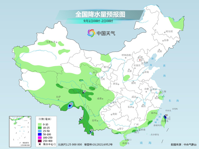
Yesterday, the rainfall in the southern region was still relatively scattered, the local rain was violent, and it was accompanied by strong convective weather such as short -term heavy precipitation and thunderstorms. Monitoring shows that northeast and southern Sichuan, northern Chongqing, central and eastern Yunnan, western and southern Guangxi, central and southern Guangdong, eastern and southern Hainan Island, central and eastern parts of Fujian, southeast Zhejiang, etc. Lijiang, Dali, Chuxiong, Wenshan, Honghe, Xishuangbanna and Guangxi Baise, Shenzhen Shenzhen, Quanzhou, Fujian, and Wenzhou, Zhejiang (100-155 mm); the largest hourly rainfall in the above areas is 30-85 mm.
According to the criteria of Huaxi Autumn Rain, on August 25 this year, Huaxi Qiuyu began from the North District, which was 18 days earlier than the beginning time of the perennial rain season in the North District (September 12). In the next three days, rainfall in the southwestern region is still more frequent.
The Central Meteorological Observatory predicts that today, there will be heavy rain in the eastern and southern parts of Tibet, southern Qinghai, northern Sichuan Plateau, western Yunnan, and Taiwan Island. Among them, there are heavy rain 50-90 mm).
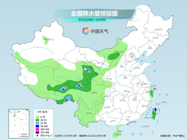
Tomorrow, there are middle to heavy rains in the Hetao area of Inner Mongolia, eastern Tibet, eastern Qinghai, central Gansu, northern Sichuan Plateau, eastern Zhejiang, and most places in Taiwan. Essence
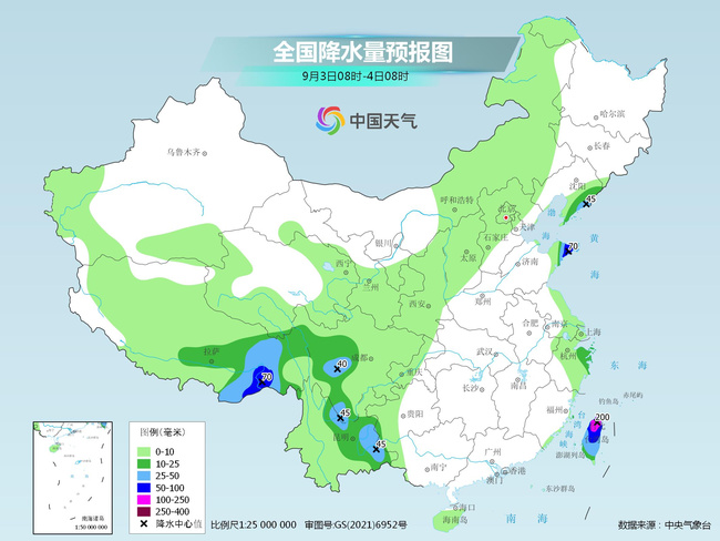
On the day after tomorrow, there are mid -to -heavy rain in eastern Tibet, western Sichuan Plateau, central and eastern Yunnan, eastern Liaoning, Shandong Peninsula, eastern Zhejiang, and Taiwan Island. Among them, southeast of Tibet, Shandong Peninsula, central and northern Taiwan is parts in parts in parts in parts of the parts of the Tibet. Rain or heavy rain (100 to 200 mm).
Generally speaking, the rainwater in some areas in Sichuan, Tibet, Yunnan and other places in the next week is almost "seeing every day". It is expected to alleviate local meteorological drought. The public needs to pay attention to the secondary disasters that may cause continuous precipitation. However, due to the lack of water vapor transportation in the south of the Jiangnan region, the drought and rain in the area of Hubei, Hunan, and Jiangxi will continue.
Most of the northern autumn will gradually become stronger, "Xuan Lannuo" will be moved into the East China Sea on the 3rd
This summer, the southern long -term and high -strength high -temperature weather process is rare. As of August 31, the highest temperatures of Chongqing, Chengdu, Hangzhou, and Fuzhou this summer have broken the highest historical record. Chongqing, Hangzhou, Nanchang, and Chengdu have exceeded the historical extreme value above 35 ° C.
As cold air penetrates south, high temperatures in the south are only in part of South China. It is expected that today, there are few high temperatures in South China, but the high temperatures from Guangdong, Guangxi, Fujian and other places will increase again tomorrow, but the scope is relatively small.
At present, most of the Northwest, western north, north, and northeast areas have entered autumn. In the next few days, most of the north will maintain a high -air weather pattern. The temperature difference between day and night is large, and the lowest temperature is mostly less than 20 ° C. The coolness will gradually increase during the morning and evening.
In addition, this year's first super typhoon "Xuan Lannuo" center was located on the northwestern Pacific Ocean on the northwestern Pacific Ocean about 510 kilometers east of Taitung City, Taiwan Province at 05.
It is expected that "Xuan Lannuo" will slowly move south at a speed of 5-10 kilometers per hour. It will stagnate or virginity in the east of Taiwan on 1-2 on the 1st. Move, moved to the south of the East China Sea on the 3rd on the 3rd, and the strength was slowly weakened.
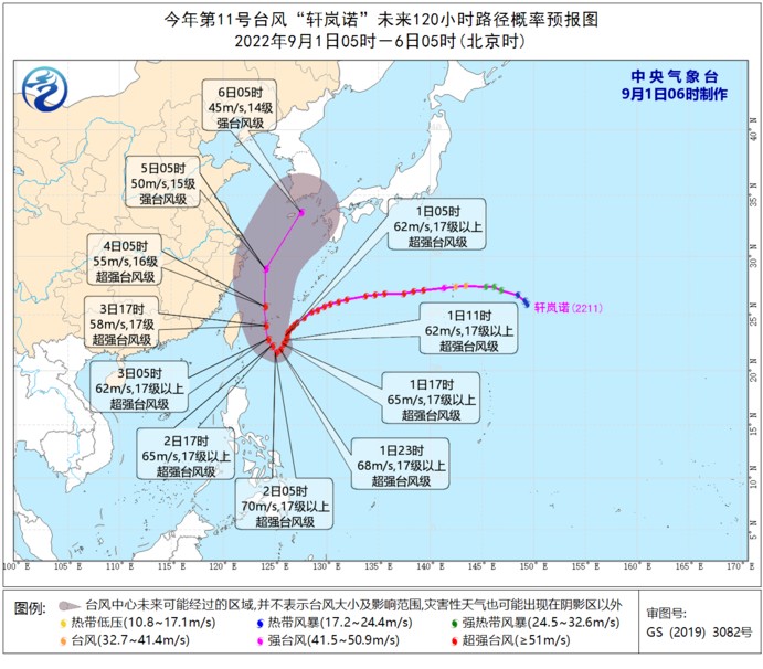
Affected by the influence of the weak and cold air south and the peripheral circulation of "Xuanlan Nuo", the wind in the East my country Sea in the early morning of September 1 will gradually increase to level 6-8, and the gust of gust is 9-10. The path forecast for the later period of Typhoon is relatively uncertain. It is recommended that the public pay attention to the nearby forecast and early warning information. Maritime operations and past ships should return to Hong Kong to avoid wind in time.
Sichuan Observation (Source: China Weather Network)
- END -
Pelosi let the Asia -Pacific market "chicken and dog restless"

The news of the US House of Representatives Perosi or visiting Taiwan made the Asi...
it is true!The train channel of Zhaoqing College will change the culvert, the construction time is .

Xijiang Daily reporter Yang YongxinRecently, the news of Zhaoqing College's entran...