"Xuan Lannuo" weakened to a strong typhoon this morning, and moved into the East China Sea on the evening of the 3rd, and gradually approached the coast of the northeast of Zhejiang!
Author:Voice of Zhejiang Time:2022.09.02
Source: Voice of Zhejiang Reporter Cai Jikang, China Weather, Zhejiang Weather
The copyright belongs to the original author, if there is any infringement, please contact it in time
"Xuanlan Nuo" weakened this morning to a strong typhoon level
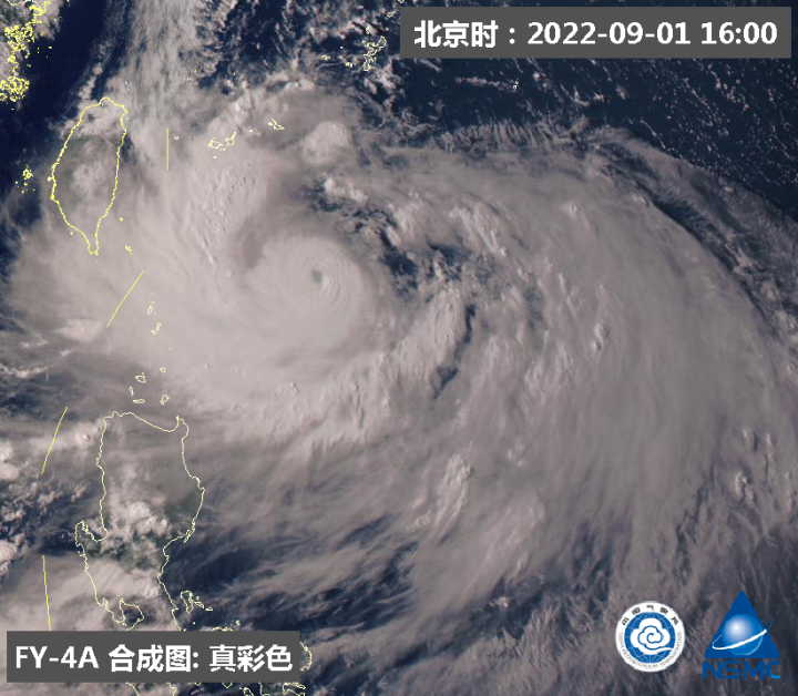
Typhoon "Xuan Lannuo" latest developments: Typhoon Xuan Lannuo (strong typhoon level) of this this this (strong typhoon), today (02) is located at 05 at 05. Above, it is 21.4 degrees north latitude, 125.4 degrees east longitude, level 15 (50 meters/s), 935 hundred Pache. It is expected that "Xuan Lannuo" will move less and move, and the intensity will weaken.

Typhoon Xuan Lan Nuo moved into the East China Sea tomorrow at night and gradually approached the coast of northeast Zhejiang
The Central Meteorological Observatory continued to issue a typhoon blue warning at 06:00 on September 2: Typhoon Xuanlan Nuo No. 11 this year has been weakened from a super typhoon level at 5 o'clock this morning to a strong typhoon. The southern part of the south of the Zhujiajian Island is about 990 kilometers on the southern ocean, and the largest wind near the center is 15 (50 meters/s).
It is expected that "Xuan Lannuo" will stagnate or rotate with the east surface in Taiwan, and the intensity will weaken. From the 3rd, it will move northward to move, move into the East China Sea on the 3rd on the 3rd. The coast is approaching. On the evening of the 4th, it will move around Zhejiang's coast to the northeast.

Dafeng forecast: September 2nd to 08:00 on the 3rd, the bus strait, Taiwan Strait, Taiwan's east ocean, most of the East China Sea, and the waters near the Diaoyu Islands, the Yangtze River Estuary Area, Hangzhou Bay, and the northern part of Taiwan and the coast of the eastern coast, Fujian, Fujian, and Fujian The coast of the central and northern parts, the coast of Zhejiang, the coast of Shanghai, and the southern coast of Jiangsu will have 6-8 strong winds, and the gusts are 9-10. "The wind on the nearby sea passed by the center is level 13-15, and the gusts can reach level 16-17.
Precipitation forecast: From 08:00 on September 2nd to 08:00 on the 3rd, some areas in eastern Zhejiang, northern Taiwan Island will have medium to heavy rain, of which there are heavy rain or heavy rain (50-110 mm) in the northern part of Taiwan Island.
- END -
Battle "epidemic" big test!Open the logistics guarantee confession point

China Well -off Network Exclusive SpecialtyText | Well -off · China Well -off rep...
Japanese media: The number of mothers on the mountain also exposed the number of mothers, and she had donated more than 100 million yen to the "unified education".

[Global Times Comprehensive Report] Japan's Yomiuri Shimbun quoted relevant source...