The first one this year, Zhejiang stopped classes in many places
Author:Global Times Time:2022.09.04
On the morning of the 4th, Typhoon "Xuan Lannuo" upgraded to a super typhoon. To this end, the Shanghai Passenger round was suspended across the board, and the city landscape lights were suspended tonight. Ningbo, Wenzhou, and Zhoushan have suspended classes tomorrow.
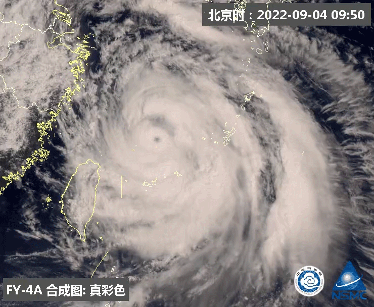
At 11:00 today (4th), Typhoon Xuan Lannuo, No. 11 this year, strengthened to a super typhoon again.
From the night of the 4th to the morning of the 5th, it will be on the north of Zhejiang's offshore sea. On the morning of the 5th, it will move to the northeast, and it will move towards the south of the Korean Peninsula to the Korean Strait.
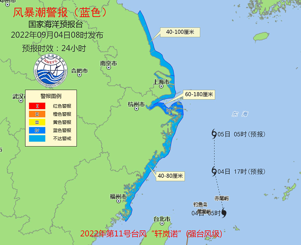
Wave red alarm and storm trendy blue alert release
On September 4th, the reporter learned from the Ministry of Natural Resources that Typhoon Xuanlan (strong typhoon "(strong typhoon) has entered the southeast of the East my country Sea in China and gradually approached Zhejiang. Affected by it, the waves of the East China Sea will continue to increase, and there will be huge waves to mad waves in the waters of Shanghai and Zhejiang. On the morning of the 4th, the National Oceanic Forecast Channel will continue to release the red alarm and storm wave blue warning.
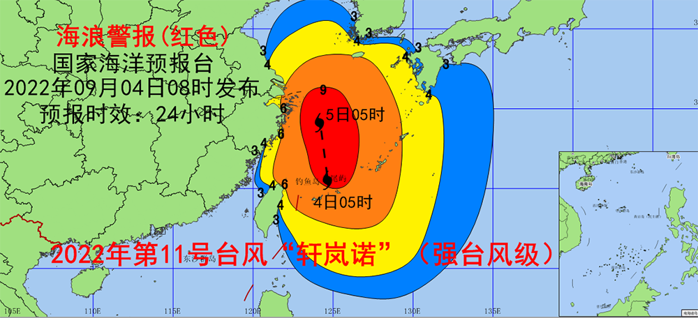
Affected by "Xuan Lannuo", it is expected that from noon from noon from September 4th to noon, the East China Sea, Taiwan will appear from 8 to 12 meters near the waters near the Diaoyu Islands to the wild wave area. ; Shanghai and Zhejiang's near -shore waters will appear 4 to 6.5 meters of huge waves to mad waves. The waves of waves near the coastal waters are red. Southern Jiangsu and the near -shore waters in the northern part of Fujian will appear from 2.5 to 4 meters to huge waves. The sea wave warning level of the near -shore waters is yellow. There will be 1.5 to 2.5 meters of medium waves to large waves in the near -shore waters in the east of Shandong Peninsula. The sea wave warning level of the near -shore waters is blue.
Zhejiang issued more than 90 various types of early warning: suspension of classes, launching emergency response to Taiwan
Affected by Typhoon No. 11 this year, "Xuan Lannuo", Zhejiang Wenzhou and Zhoushan have issued emergency notifications. The city's primary and secondary schools, kindergartens, and off -campus training institutions suspended classes on September 5 for 1 day in reference in colleges and universities in the city. At 18:00 on the 3rd, Zhejiang's emergency response to Typhoon Affairs was raised to Class II. As of 12:20 on the 4th, the province had released 90 various types of early warning information.
"Wenzhou Release" WeChat public account September 4 news, today's "Xuanlan Nuo" seven-level wind circle gradually covers most of Wenzhou areas, and level gusts of 8-10 gusts will appear in land. Affected by it, Wenzhou Airport launched a three -level response at 10:37 on September 4, 2022 at 10:37.
On the afternoon of the 4th, due to the influence of the super typhoon "Xuan Lannuo", Ningbo City, Zhejiang decided: all primary and secondary schools, kindergartens, and off -campus training institutions in the city were suspended on September 5th (Monday) for one day. The decision to judge the business again, with reference to the implementation of Ningbo universities.
According to the trend and development trend of typhoon, the Ningbo Maritime Safety Administration decided to enter the junction of the IIIIIIT -level defense station from 14:00 on September 4th.
As of noon today, Ningbo had more than 5,400 ships in Hong Kong, of which nearly 4,000 fishing vessels. In addition, 25 sea cruisers and 65 trailers (including 9 high -horsepower trailers) have fully entered the emergency response status, assisting some powerless ships to do a good job of evacuation, and providing emergency materials for some temporary entry into Hong Kong to avoid ships.
The maritime department reminds that after the release of the emergency response of the Grade III Taiwan, the crew on duty on the Hong Kong Ship Ship Ship Ship Ship Ship Ship Ship Ship Ship Ship Ship Ship Ship Ship Ship Ship should receive Meteorological Information and Port Defense Information in time through radio communication equipment. Caused an anchor. In the case of danger, call the national water in time to ask for help 12395.
Shanghai: Suspension of landscape lighting, passenger ships suspended
Affected by the periphery of "Xuan Lannuo", rain and windy weather appeared in Shanghai. Statistics accumulated the rainfall at 08 to 4 on September 3rd. 29.9mm (16:33 to 17:33 on the 3rd). The maximum gust of land has reached 7 levels, and the largest gust of gust of gusts of Yangshan Port District and Shanghai coastal seas is 9-10. The largest wave of the coastal sea surface of Shanghai is as high as 5-8 meters.
In terms of strong winds, the wind will increase from the afternoon of September 4th. During the strongest period of influence, the 4th to the 5th day, the largest inland gust is 7-9 levels, and the coastal areas along the river 9 to 11 areas. It reaches level 11 to 13, and the wind has decreased significantly from the 6th.
In terms of rainfall, the main precipitation period is from 4 to 5 during the day, and the cumulative rainfall can reach 30 to 50 mm. It is 60-90 mm along the coast of the river. The possibility of focusing on strong precipitation.
The Shanghai Meteorological Department stated that it will upgrade the typhoon blue early warning signal of the typhoon blue this afternoon, and pay close attention to the typhoon dynamics and the impact on Shanghai's storms, and report the latest situation in a timely manner.
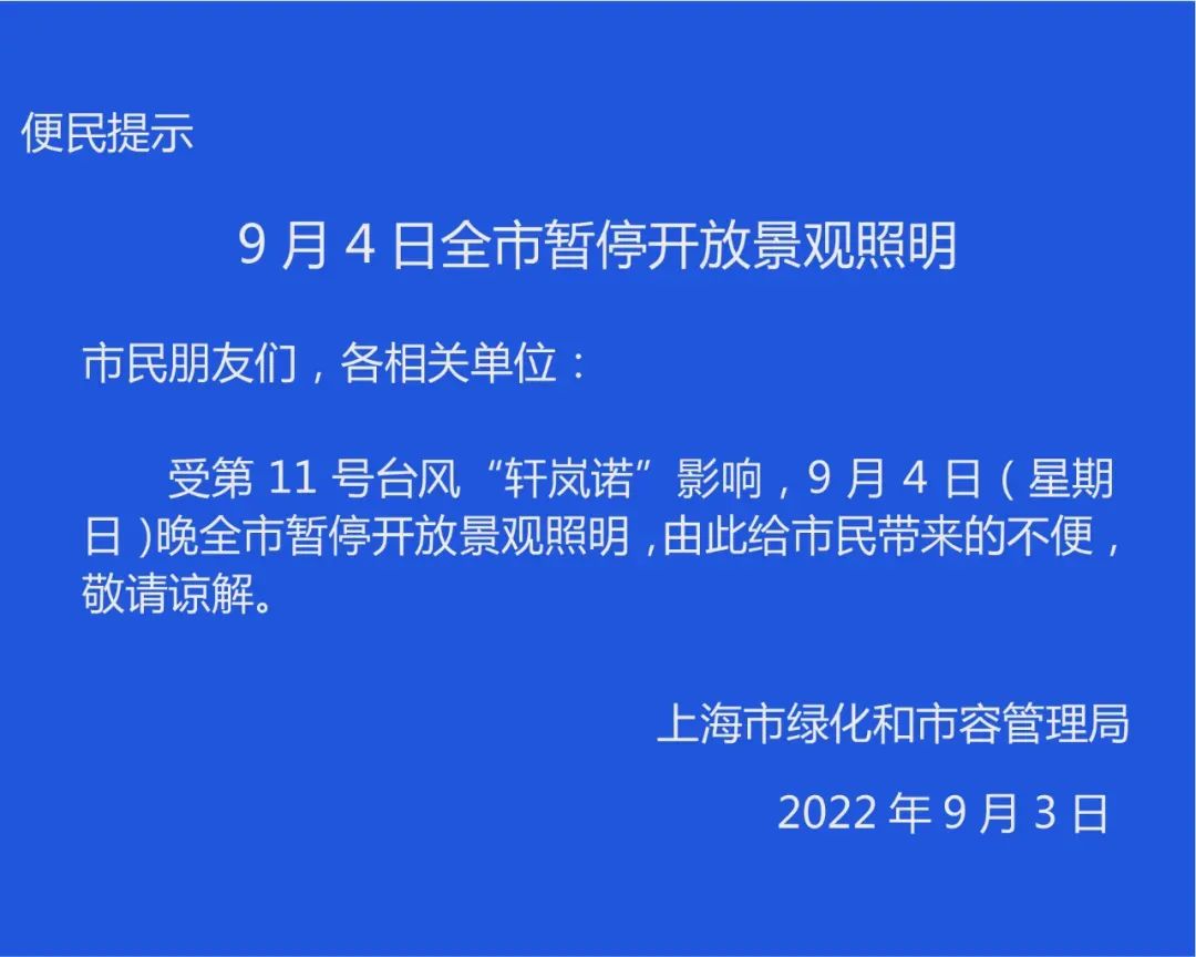
On the evening of September 3, the Shanghai Greening and Municipal Rong Administration issued a notice: Affected by Typhoon No. 11 "Xuan Lannuo", on September 4th (Sunday), the city was suspended in the city. ,beg to be excused.
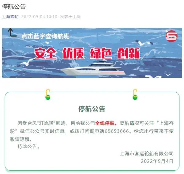
"Shanghai Passenger Wheel" WeChat public account September 4 news, due to the influence of Typhoon "Xuan Lannuo", Shanghai Passenger Shipping Co., Ltd. is currently suspended.
The less typhoon this year is related to the influence of the La Nina incident
Along with the typhoon "Xuan Lannuo", there have been many questions on the Internet: why did the first super typhoon not coming in early September? The trajectory of Typhoon "Xuan Lannuo" is quite strange. What is the reason? What impact of typhoons will bring on my country's coastal areas?
With these issues, the reporter of "Daily Economic News" conducted a telephone interview with Zhu Dingzhen, chief expert of the Meteorological Service Center of the China Meteorological Administration's Public Meteorological Service Center. The first super typhoon was ushered in the year at the end of August and early September. For most ordinary people, the first reaction was that this typhoon was "a bit late."
In this regard, Zhu Dingzhen said in an interview with the reporter of the Daily Economic News that this is not only the problem of super typhoons. In fact, the overall time of the typhoon this year is too late, and the number of typhoons is small. Typhoon is equally small.
What is the reason for this phenomenon? Zhu Dingzhen analyzed to reporters that first of all, the number of typhoons was related to the impact of this year's La Nina incident.
Generally speaking, the generation of typhoons requires sea temperature and the circulation conditions that are beneficial to the survival of typhoons, but the emergence of the La Nina incident has caused the circular conditions to weaken compared with the year. Essence
In addition, the phenomenon of less typhoons is also closely related to the long time of high temperature weather this year. The direct reason for the continuous high temperature is the abnormalities of atmospheric circulation and the abnormal distribution of the subtropical high pressure this year, and the abnormal distribution of the subtropical high pressure also causes abnormal circulation of the typhoon activity area on the south side of the subtropical high pressure, which is not conducive to the development of typhoons.
"Daily Economic News" reporter noticed that the first super typhoon in 2020 did not only appear until the end of August and early September: at 05 on September 1 of that year, Typhoon Michard "Masak" was strengthened to super typhoon It became the first super typhoon during the year.
Source: Observer Network Comprehensive
- END -
Night Reading | Practicing yourself

Source: Rufeng everyoneAuthor: Rufeng everyone · expedition girlEdit: Liu QianThe...
Unexpected injuries to the disability to pay for paying for the victim to execute the judge to solve your worries

Tianshan News (Reporter Yang Shuhan reported) If it was not an executive judge, I ...