"Plum Blossom" is promoted to a strong typhoon level!Just now, Zhejiang three places launched a typhoon emergency response at sea!
Author:Zhejiang Firefigh Time:2022.09.11

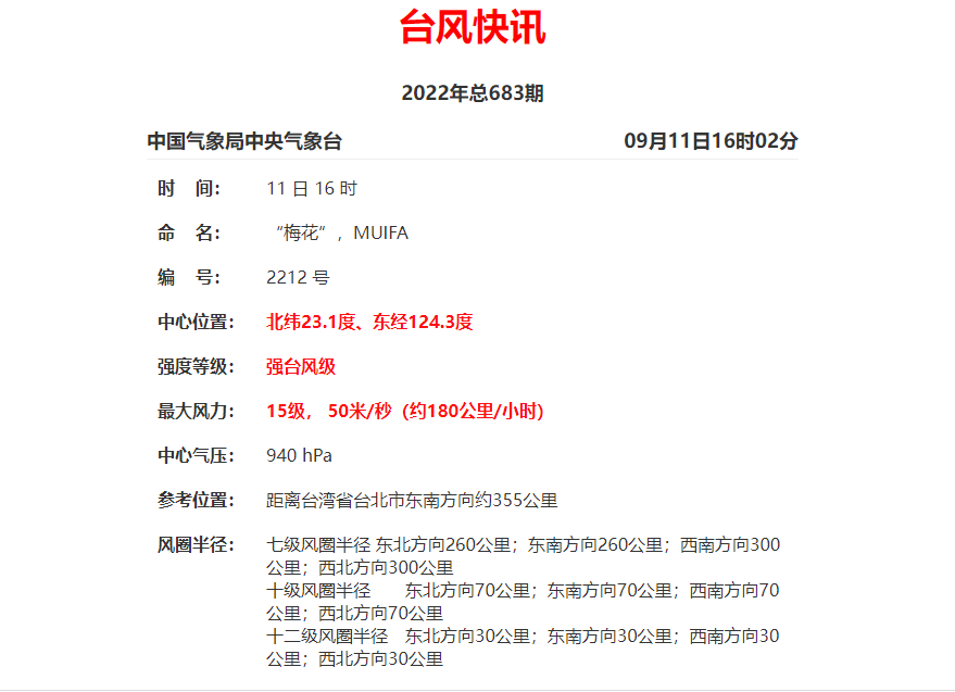
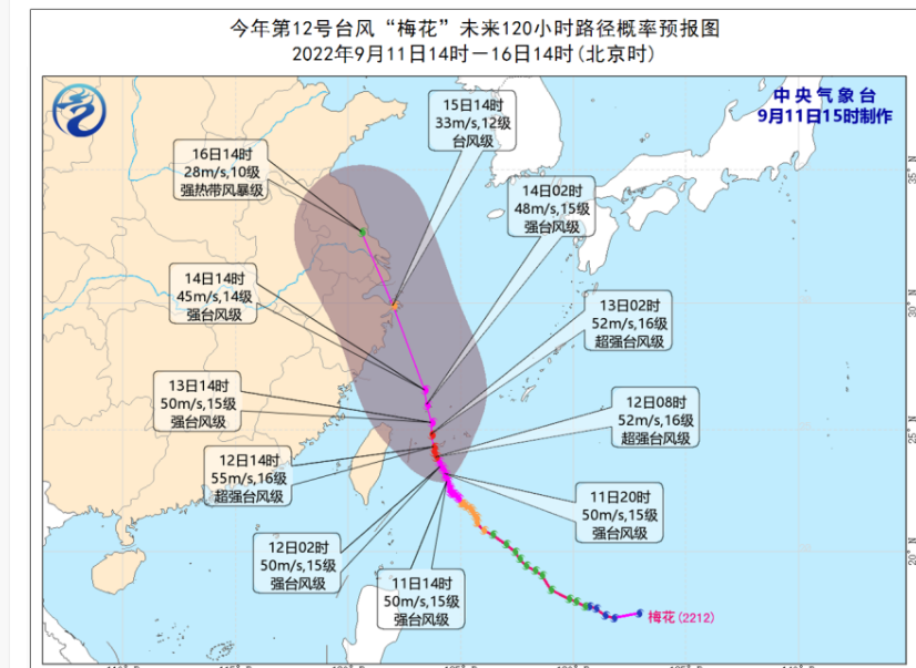
Typhoon "Plum Blossom" (strong typhoon "(strong typhoon) this year is located on the center of about 385 kilometers from the southeast of Taipei, Taiwan Province. Western movement. Tomorrow night through the Ryukyu Islands and entering the southern waters of the East China Sea, they gradually approached Zhejiang coast.
Taizhou launched a typhoon prevention level IV emergency response
According to the emergency plan of the Flood Control Station in Taizhou, the city's defense finger decided to launch a sea -level emergency response at the sea of typhoon prevention at 15:00 on September 11. All localities and departments are requested to do a good job of the typhoon "plum blossom" in accordance with the plan.
Ningbo launched the emergency response of typhoons at sea
According to the "Ningbo City Flood Control and Drought Resistance Emergency Plan", the city's defense index decided to launch an emergency response to typhoon prevention at 14:00 on September 11. Relevant departments in various places are requested to pay close attention to the dynamics of "plum blossoms" and do a good job of defense according to the plan.
Wenzhou launched a typhoon prevention level IV emergency response
According to the "Wenzhou Flood Prevention and Drought Resistance Emergency Plan", the municipal defense index decided to launch a typhoon prevention response to the typhoon prevention level IV emergency response at 12:00 on September 11. Members of all localities are requested to do a good job in the "plum blossom" typhoon defense work in accordance with the requirements of the plan.
Zhejiang waters may appear 10 meters mad waves
There are already fishing boats back to Hong Kong to avoid wind
This Mid -Autumn Festival holiday, the typhoon "plum blossom" meets the narrow road of the annual astronomical tide.
At 10 am today (September 11), the Zhejiang Provincial Marine Monitoring and Forecast Center released the news of the storm and waves.
Affected by Typhoon Plum (strong typhoon level) No. 12 this year, it is expected that from the 13th to 15th, a typhoon storm process will occur along the coast of our province.
It is expected that from the 13th to 15th, a large storm process will occur in the waters of Zhejiang Province, with a maximum of 14-15. 8.0 meters to 10.0 meters of mad waves will appear from the waters of Zhejiang Province.
News from the Provincial Agricultural and Rural Hall, affected by the tide and storms caused by typhoons, before 10 o'clock tonight, the fishing vessels in the operation of 27 ° north latitude of Zhejiang Province will return to Hong Kong to avoid wind.
From tonight to tomorrow, a large number of ships will return to Hong Kong to avoid wind. The fishing vessels will now catch the East China Sea fishing and will be concentrated in the coastal fishing boat terminals and seafood markets.
Originally, September 16th was the big day of fishing in the East China Sea. More than 19,000 fishing vessels in Zhejiang will be lifted across the board to restore maritime operations.
The relevant person in charge of the Provincial Agricultural and Rural Department said that from the current situation, due to the influence of the typhoon "plum blossoms" at sea, the East China Sea opened on September 16 this year or will be postponed.
"Plum Blossom" affects Zhejiang
May be greater than "Xuanlan Nuo"
According to typhoon monitoring, even if "plum blossoms" will not land on the coast of East China in the future, it is expected to be more west than the path of the previous typhoon "Xuan Lannuo". Although the intensity of "plum blossoms" is not as good as "Xuan Lannuo", it is closer to closer to closer The coast of Zhejiang and Shanghai, combined with the influence of cold air, is expected to have the impact of "plum blossoms" on the wind and rain of Jiangsu, Zhejiang and Shanghai.
Of course, the current "plum blossoms" are still a certain distance from us, and the uncertainty is relatively large. We also hope that "plum blossoms" is a "good typhoon" that can not be hydrated.

In the next week
Or there will be two typhoons generated
In addition to the "plum blossoms", the northwest Pacific mid -latitude ocean is also active on the two tropical disturbances of 92W and 93W. These two tropical disturbances will have a high probability to strengthen Typhoon No. 13 and 14 this year.
Especially the tropical disturbance of 92W, after ending the double typhoon interoperability effect with "plum blossoms", it has been wandering on an ocean surface nearly 1,500 kilometers from Japan. 92W will continue to move west in the next 3 days, and the strength will be gradually enhanced. In the later period, it needs to pay attention to changes in its path and strength, and the possible impact on my country.
The weather trend in the later period
13-17
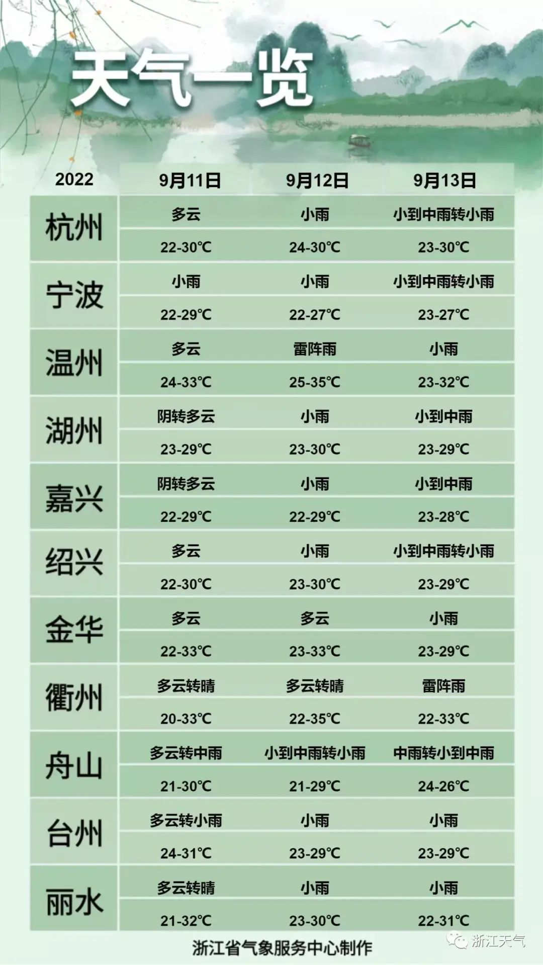
Our province is affected by the typhoon "plum blossom"
Rain starts to increase
Especially 14-15
It is expected to be in the eastern part of Zhejiang to heavy rain
Need to prevent prevention in advance!
Source: Central Meteorological Observatory, Zhejiang Weather, Zhejiang News


- END -
Pork was detected for prohibited medicines, Longda Food and Sales Hotel each word each

Recently, the Qingdao Municipal Supervision Bureau announced a notice on food safe...
The Interim Measures for the Management of Zhengzhou Automobile Hydrogenation Station
The interface Henan learned from the Zhengzhou Municipal People's Government on August 9 that the Interim Measures for the Management of the Hydrogenation Station of Zhengzhou Automobile was recentl...