Update 丨 Zhoushan's typhoon anti -emergency response adjustment to level III!Zhoushan cross -sea bridge and 7 bridges on the island unblocked
Author:Zhejiang Daily Time:2022.09.15
Zhejiang News Customer Reporter Zheng Yuandan He Yizheng Huang Ninglu Correspondent Wang Yuxin
Typhoon "Plum Blossom" (strong tropical storm) this year is located in the east of Yancheng, Jiangsu at 8 o'clock, namely 32.7 degrees north latitude, 120.8 degrees east longitude, 985 hundred Pachen in the center, and the maximum wind of the center in the center. The speed continues to move northwest, and the intensity gradually weakens.
In accordance with the "Flood Control Drought Prevention and Taiwan Emergency Plan", the city's defense index was decided to adjust the typhoon prevention level Ⅱ emergency response to level III at 9:00 on the 15th.
Update at 7 o'clock on September 15:
At present, according to the "Drinking Drought Prevention and Taiwan Emergency Plan" in Zhoushan City, the city defense index is decided to adjust the typhoon prevention response to class Ⅱ at 6 o'clock on the 15th.
Zhoushan high -speed traffic police remind: 6: 35 in the morning, G9211 Yongzhou high -speed, S6 Dingye high -speed roads were lifted, and normal traffic was restored. Please pay attention to keeping the car distance and control the speed of the vehicle.
At present, 7 bridges such as Zhujiajian Bridge, Guanyin Bridge, Lujiayu Bridge, Puxi Bridge, Hong Kong Island Bridge, Xincheng Bridge, and Laoshan Bridge have ended traffic control and resumed normal traffic.
Update at 23:50 on September 12th
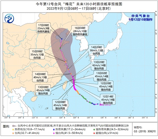
Typhoon "Plum Blossom" (Typhoon Grade) No. 12 this year is located at 590 kilometers south to southeast of Zhoushan at 23, that is, 24.9 degrees north latitude, 124.0 degrees east longitude, 960 hundred Pache in the center, and the maximum wind of the center of the center 13. It is expected that "plum blossoms" will move north to west of 5-10 kilometers, and gradually approach the coast of the northern part of our province. The maximum is likely to land on or passing through the Zhoushan Islands on the night of the 14th. class.
At 19:30 on September 12th:
At 19:20 on September 12, due to the influence of rainy weather, the G9211 Yongzhou high -speed full bridge section was 80km/h. In the past, the driver should pay attention to driving safety, control the speed of the vehicle and the distance, and do not drive fatigue.
Update at 16:20 on September 12:
The headquarters of the Flood and Drought Control of the Zhoushan Municipal People's Government issued a notice on the emergency response of typhoons to the III level:
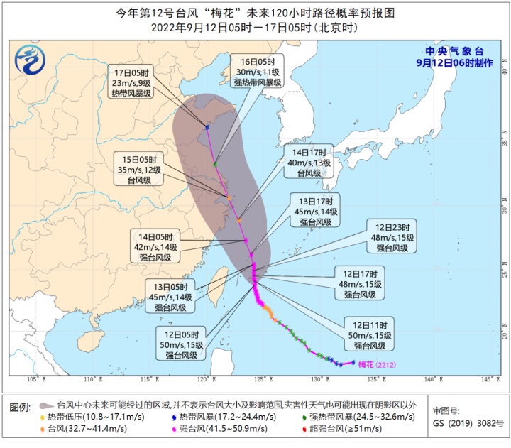
Typhoon "Plum Blossom" this year weakened to a typhoon level at 14:00 today. It is 610 kilometers south of Zhoushan to the southeast, that is, 24.7 degrees north latitude, 124.0 degrees east longitude, 960 hundred Pache in the center, and the maximum wind of the center of the center. It is expected that "plum blossoms" will move north to west of 5-10 kilometers, and gradually approach the coast of the northern part of our province. The maximum is likely to land on or cross the north of the Zhoushan Islands on the morning of the 14th to the morning of the 15th. For typhoon level. Affected by the circulation of the typhoon and the weak cold air, there is a middle to heavy rain in Zhoushan City this afternoon to tomorrow. Local rainstorms are accompanied by lightning (cumulative rainfall 50-100 millimeters, and local 100 mm or more). The coast of Zhoushan will start at 8-9 at noon tomorrow at noon tomorrow, and the day after tomorrow will be strengthened to level 9.
In accordance with the "Drinking Drought Prevention and Taiwan Emergency Plan", the city defense index was decided to increase the typhoon prevention response to level III at 16:00 on September 12.
The Zhoushan Meteorological Observatory was released at 15:30 on September 12:
Affected by the flow of the periphery of the typhoon and the weak cold air, at 20:00 on the 11th to 15:00 on the 11th, the face rain was set with 30-40 mm, Putuo was about 15 mm, Shengsi 5 mm, the maximum town of the town was 111.7 mm, and the largest hour rainstream rain. 49.6 mm (10-11 o'clock) in Qiang Xiushan Township. It is expected that the total rainfall of the process of 12-15 days is 150-200 millimeters, with a local 250 mm or more, and more than 300 mm. Among them, there is a middle to heavy rain in the yin of Zhoushan City this afternoon to tomorrow. Local 100 mm or more), 14-15 days of rainfall 100-200 millimeters, local 250 mm or more, precipitation is mainly concentrated on the night of the 14th to the morning of the 15th. There will be a short-term heavy precipitation of about 50 mm in the hour. Please strengthen the geology. Disasters and small watersheds.
The coast of Zhoushan will start at 8-9 at noon tomorrow at noon tomorrow, and the day after tomorrow will be strengthened to level 9, and the northwind is 10 to the 12th level of the day after night. It will rotate the wind at level 14 at the middle of the night to 15th.
Update at 13:00 on September 12:
The typhoon news and heavy rain alerts were released at 15 o'clock on September 12, 2022: September 12, 2022:
Typhoon "Plum Blossom" (typhoon level) No. 12 this year, is about 610 kilometers south of Zhoushan to the southeast today at 14 o'clock, that is, 24.7 degrees north latitude, 124.0 degrees east longitude, 960 hundred Pachen in the center, and the maximum wind of the center of the center. The speed of 5-10 kilometers is moved north to the west. It is expected to enter the southern seas of the East China Sea today, and continue to move north to the west, and gradually approach the coast of central and northern Zhejiang.
Affected by the flow of weak and cold air and the periphery of the typhoon, there will be shower or thunderstorms in Yin, Zhoushan City today, and tomorrow. It is expected that the coast of Zhoushan will start to the northeast wind at noon tomorrow at noon, and the east to the northeast wind will be strengthened to level 9. Please pay attention to prevention.
Update at 12:00 on September 12:
The typhoon news and heavy rain alerts were released at 11 o'clock on September 12, 2022: September 12, 2022:
Typhoon "Plum Blossom" (strong typhoon "(strong typhoon level) this year is located at 10:00 today to 670 kilometers south southeast, that is, 24.2 degrees north latitude, 124.2 degrees east longitude, 950 hundred Pachen in the center, and the maximum wind of the center of the center. At present It moves north at 5-10 kilometers to the west. It is expected to enter the southern seas of the East China Sea today, and continue to move north to the west, and gradually approach the coast of central and northern Zhejiang. Affected by the flow of weak and cold air and the periphery of the typhoon, there will be shower or thunderstorms in Yin, Zhoushan City today, and tomorrow. It is expected that the coast of Zhoushan will start to the northeast wind at noon tomorrow at noon, and the east to the northeast wind will be strengthened to level 9. Please pay attention to prevention.
The Zhoushan high -speed traffic police reminded that due to the influence of rainy and weather, the G9211 Yongzhou high -speed full bridge section is 60km/h. Please pay attention to "speed reduction, control, bright tail".
It comes from the Central Meteorological Observatory website
The waves yellow alert! Typhoon No. 12 "Plum Blossom" will cause some waters in Zhejiang to mad waves
The Zhejiang Marine Monitoring and Forecast Center issued a yellow warning of the waves based on the "Emergency Plan for the Marine Disaster".
Affected by Typhoon No. 12 "Plum Blossom" (strong typhoon level), it is expected to be noon today to noon tomorrow:
(1) The sea area: Hangzhou Bay has a light wave of 0.6 meters to 1.2 meters, and it will increase to 1.2 meters to 1.8 meters at noon tomorrow; there will be a middle wave from 1.6 meters to 2.2 meters in northern Zhejiang. From 3.0 meters to 4.0 meters to huge waves; there are mid -to -large waves from 2.0 meters to 3.5 meters in central Zhejiang, and will increase to large waves from 3.5 meters to 5.0 meters tomorrow at noon; As large as huge waves, it will increase from 4.5 meters to 6.5 meters at noon tomorrow. The warning level of the sea waves in the sea is yellow.
(2) Near -shore waters: Zhoushan is from 1.0 meters to 1.6 meters of light to Zhonglang, and will increase from 2.0 meters to 3.0 meters from the middle to large waves tomorrow. Increase to the middle of 2.0 meters to 3.0 meters; there are 1.2 meters to 2.0 meters from the waves from 1.2 meters to 2.0 meters, and the large wave from 2.2 meters to 3.2 meters tomorrow will be increased; Wenzhou has 1.4 meters to 2.2 meters of middle. The waves will increase to a large wave from 2.5 meters to 3.4 meters tomorrow at noon. Near -shore sea wave early warning level is blue.
Update at 7 o'clock on September 12:
The typhoon news and heavy rain alerts were released at 6 o'clock on September 12, 2022: September 12, 2022:
Typhoon "Plum Blossom" (strong typhoon "(strong typhoon level) this year is about 730 kilometers south of Zhoushan to the southeast today, namely 23.7 degrees north latitude, 124.2 degrees east longitude, 940 hundred Pachen in the center, and the maximum wind power in the center of the center. At present It moves north at 5-10 kilometers to the west. It is expected to enter the southern seas of the East China Sea today, and continue to move north to the west, and gradually approach the coast of central and northern Zhejiang.
Affected by the flow of weak and cold air and the periphery of the typhoon, today and tomorrow, there is a middle to heavy rain in Zhoushan City. It is expected that the coast of Zhoushan will start to the northeast wind at noon tomorrow at noon, and the east to the northeast wind will be strengthened to level 9. Please pay attention to prevention.
It comes from the Central Meteorological Observatory website
The Central Meteorological Observatory posted a defense guide:
1. Government and relevant departments do a good job of preventing typhoon rescue emergency in accordance with their duties.
2. Related water operations and past ships should return to the port to avoid wind, strengthen port facilities, and prevent the ship's anchor, stranding and collision.
3. Stop outdoor dangerous operations such as large -scale rally indoor and outdoor and high altitude.
【Previous news】
At 18:10 on September 11th:
The Command of the People's Government of Zhoushan City Flood Control, Drought Control and Taiwan issued a notice on the start of typhoon prevention level IV emergency response:
Typhoon "Plum Blossom" No. 12 this year was generated at 8 am on September 8th at the east of the Philippines. After generation, it moved to the northwest. The intensity gradually increased. The kilometer, that is, 23.1 degrees north latitude, 124.3 degrees east longitude, 940 hundred Pachen in the center, and the maximum wind power of the center of the center is 15th. Currently, it will move north to the north at 5-10 kilometers. It is expected Westward movement, and gradually approached the coast of central Zhejiang.
In accordance with the "Flood Control Drought Prevention and Taiwan Emergency Plan", the city's defense index decided to launch a typhoon prevention response at 18:00 on September 11. All localities and departments are requested to continue to pay attention to the latest trends of typhoons and do a good job of typhoon "plum blossoms".
The picture comes from the Central Meteorological Observatory website
At 17:30 on September 11th:
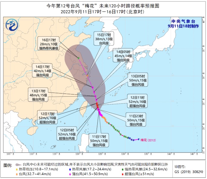
At 16:00 on September 11, the center of Typhoon "Plum Blossom" (strong typhoon) this year was about 355 kilometers southeast of Taipei City, Taiwan Province. The maximum wind in the center has been upgraded to 15 (48 meters/s). It is expected that "plum blossoms" will slowly move north at a speed of 5-10 kilometers per hour, and the intensity will not change much.
According to typhoon monitoring, even if "plum blossoms" will not land on the coast of East China in the future, it is expected to be more west than the path of the previous typhoon "Xuan Lannuo". Although the intensity of "plum blossoms" is not as good as "Xuan Lannuo", it is closer to closer to closer The coast of Zhejiang and Shanghai, coupled with the influence of cold air, is expected to have the impact of "plum blossoms" on the wind and rain of Jiangsu, Zhejiang and Shanghai.
According to the Central Meteorological Observatory, the "Plum Blossom" will continue to move northwest on the evening of the 12th. After passing through the Ryukyu Islands, enter the southern sea surface of the East China Sea. It will gradually approach the coast of the eastern part of Zhejiang. Update at 12 o'clock on September 11:
The reporter learned from the Zhoushan Meteorological Observatory that Typhoon "Plum Blossom" (strong typhoon) this this this this year is 880 kilometers from the south to southeast of Zhoushan, that is, 22.4 degrees north latitude, 124.7 degrees east longitude, 955 hundred Pacana in the center, near the center, near the center The maximum wind power is 14, and it will move north at a speed of about 10 kilometers per hour, and the intensity will gradually strengthen. This means that the possibility of "plum blossoms" in the coastal area of East China increased.
The Typhoon Alert of the Fishing Grounds has been issued by the Zhoushan Meteorological Observatory. Affected by it, the fishing ground will increase from south and north tomorrow. Please pay attention to prevention.
According to the news released by the Central Meteorological Observatory, it is expected that "plum blossoms" will move northwest at a speed of 15-20 kilometers per hour, and the intensity will gradually increase, the strongest can reach 45-50 meters/s (14-15, strong typhoon) Essence On the evening of the 12th, the intensity began to weaken slowly, and continued to move northwest. After passing through the Ryukyu Islands, entered the southern sea surface of the East China Sea. It gradually approached the coast of the eastern part of Zhejiang.
Today is also the second day of the Mid -Autumn Festival holiday, and there are still good weather blessings. Zhoushan is cloudy today, and there is a shower. Today, the yin is in the middle of the morning to the heavy rain, and the local heavy rain. The city's highest temperature is 30 ° C today, and tomorrow's temperature is 23-28 ° C. The coast of Zhoushan is on the coast of the sea.
- END -
Shanxi reports to multiple epidemic prevention and control over control over control over control and control

On the 15th, the reporter learned from the Office of the Leading Group of Logistic...
A shooting in a bar in South Africa, at least 15 people died

Jimu Journalist Hu LiIntern Yang XingnanAccording to CNN, on July 10, local time, ...