Ocean or container crust?Iceland or Iceland?This is a question worth discussing
Author:Astronomy online Time:2022.09.28
Under Iceland, the "lost continent"
Iceland may be a corner of sinking the continent
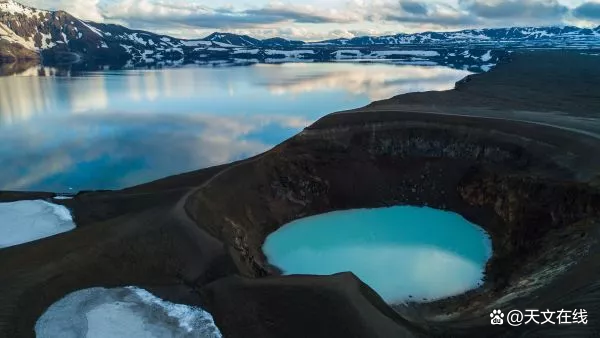
(Illustration: Snow Mountain in Akareli, Iceland. Source: Norbert Figueroa/Eyeem Via Getty Images)
According to the new theory proposed by a team of international geological physicists and geologists, the "Iceland continent" sank at the North Atlantic about 10 million years ago. Iceland may be the latest "Iceland continent" relic.
This theory runs counter to the theoretical formation of Iceland and North Atlantic, but scholars say that the theory not only explains the cause of the geological characteristics of the ocean, but also explains why the crust below Iceland is far thick than the average ocean crust. Outsiders who have not participated in the study told Live Science that according to existing evidence, they were skeptical of the existence of the Icelandic continent.
Even so, once geological research confirms the theory, this new idea about the sinking continent will affect all the ownership of all the fuel foundation below the underwestern sea. International law stipulates that these fuels belong to countries that can prove their continental crust to the bottom of the sea area.

Gillian Foulger, a professor of geography at Duoren University in Britain, is the new book "Wallen Hamilton: The Footsteps of Warston B. Hamilton: New Ideas In the first author of the Icelandia (Icelandia "in Earth Science, this chapter explains this new theory. "This area has been extended from Greenland to the Scandinavia Peninsula, and there are crustal substances under it," Folg said. She also told her life science: "On both sides of this area, some parts have sinking underwater, but it is still much higher than the general situation ... ... If the sea plane drops 600 meters (2000 feet), we will See more land on the sea. "

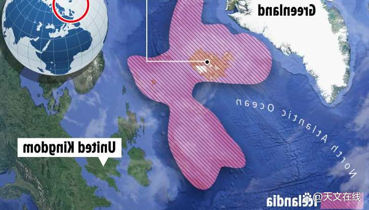
(Illustration: 10 million years ago, the "Iceland continent" may have been stretched between Greenland and the Scandinavian Peninsula, and a area where British and Western Ireland may be sinking may constitute part of the "Great Iceland continent". Picture source: Gillian Foulger/Google Map)
Lost continent
Formu said that the North Atlantic region was completely land, and it constituted part of the super Pangu continent that existed from 335 million to 175 million years ago. Geological scientists have always believed that the North Atlantic Sea Basin, which constitutes the Pangu continent, began to disintegrate 200 million years ago, while Iceland was formed above the volcanic feathers near the center of the ocean.
Folg and the research co -authors proposed different theories: During the division of Pangu continent, the ocean was roughly formed from the northern and southern parts of Iceland (instead of the east and west). Geologists also wrote that the eastern and western regions were connected to the current Greenland and Scandinavian Navia Peninsula.
"People's ideas are very simple. They think that the crust section is like a dining plate: it will only be divided into two and then separate each other," Forter said. "But the crust section is more like a pizza, or a variety of materials systems are made of multiple materials systems. The artwork of it -partly is the fabric and the other part is ceramics, so the strength of different parts is different. "
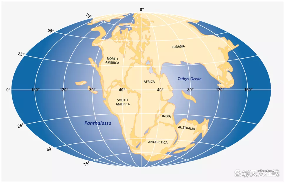
(Graphic: In the history of 4.5 billion years of the earth, the continent on the earth was considered to have collided many times and split again. The recent super continent was Pangu continent, which started to split about 200 million years ago. Formed the Pangu continent The mainland finally entered the current mainland structure. Source: Getty Images)
Folg told us that the new theory believes that Pangu continent has not completely fallen apart. The lost Iceland continent was still 200 miles wide (300 kilometers) on the sea until 10 million years ago. So only Iceland was left on the sea.
Geologists also said that if Iceland is formed on volcanic feathers, its ground shell rock should be about 5 miles (8 kilometers) thick, but it is actually about 25 miles (40 kilometers) thick. Under the new theory, this question is understood.
"Once the crustal rocks here may be part of the mainland, our data suddenly speaks," Form said in the statement. "This immediately realized that the former mainland area was far more than Iceland. It is much bigger -the hidden mainland is under the sea. "

Continental shelf
Form and her colleagues predict that the Icelandic continent has stretched more than 230,000 square miles (600,000 square kilometers) between Greenland to the Nakkannian Peninsula, which is a little smaller than Texas. (Today, Iceland has about 40,000 square miles, that is, 103,000 square kilometers.)
They suggested that there was a similar area of similar sizes in today's British and Irish, and it constituted the "Great Iceland continent" with the area, and the area had been sinking under the waves.
(Illustration: Scholars believe that the "Iceland Continent" is hidden under Iceland and the surrounding ocean.
Fossil evidence shows that the same plants that are breeded in the Narvia Peninsula on Greenland and Scandinavia have appeared. Research authors believe that this discovery makes people even more believed that there was a wide land connected to two areas. However, geologists do not know whether the fossil evidence of animal fossils exist on the lost continent. PHILIP Steinberg, a geography scientist at the Duoren University Border Research Center in the United Kingdom, said the new theory of Iceland in the Icelandic continent may affect the ownership of fossil energy buried in the sea. International law stipulates that when fossil energy can be proven to be stored in the continental shelf of a country (the relatively shallow area of the sea, it can extend to a few hundred miles from the coast), the country can claim to have these fossil energy sources.
Stanberg did not participate in the Iceland's research project. He pointed out that countries around the world are investing a lot of funds for geological research to declare exclusive rights for mineral resources under their respective continental racks.
"For example, the research of Professor Forts forced us to rethink the relationship between the sea bed and the continental geology, and at the same time, it will also have a profound impact on countries that want to determine the exclusive rights of the sea bed." Stanberg said in a statement.
The concept of the Iceland continent is contrary to the mainstream North Atlantic region. Many well -known geologists and earth physicists have also criticized the idea.
Geologicalist Ian Dalziel, a geologist at the University of Texas University, won the Penros Medal with the research work of ancient geography and ancient mainland. Any reason to prove the rationality of the proposal.
Darzier told life science in the email that the Iceland continent is different from the sinking continent. For example, the latter has been confirmed by geologists to be composed of the sinking continental crust after being separated from Antarctica, and the North Atlantic is not enough to form a continental crust material on the Icelandic continent.
(Illustration: Mainland China is the "lost continent" of the sinking. In the South Pacific, there is a territory of New Zealand and New Caerdonia. Here is a part of it. The source of the picture. Source: Arne Hodalic (Arne Hodalic ) Via Getty Images)
The director of Oslo Earth evolution and dynamics, the director of the Geophysicist Carmen Gaina, and Alexander Minakov, Alexander Minakov at the University of Oslo, told life science in the email that the "Iceland continent" is a "boldness" There are many problems with it, and it is unlikely to exist in the Icelandic continent.
For example, they said that the magnetic exploration of the bottom area of the sea showed "stripes", showing that during millions of years, when the polarity of the earth's magnetic field changed, when the layers of lava continued to spread on the bottom of the North Atlantic Ocean; this Planting "stripes" is the sign of the ocean crust, which can also be seen in the large Pacific Ocean -based plateau.
(Illustration: "Nature" reports that in the past 20 million years, the earth's magnetic pole reversal will appear every 200,000 to 300,000 years. Inside, the magnetic pole began to stay away from the self -rotary axis until the final change. In the past 20 years, as the magnetic Bei pole moves, the meridian of the first child moves north at a speed of 34 miles/year.)
Nevertheless, "their conceptual views are a good starting point for discussions and have more important starting significance for the collection of more related data," Gana and Minokov said. For example, it is conducive to further marine geological drilling and earthquake exploration (that is, to measure the crust through seismic waves after the scientific ship performed a quantitative explosion).
By: Tom Metcalfe
FY: Bowl of Shengjiu Barball
If there is related content infringement, please contact the author to delete after the work is released
Reprinted, please obtain authorization, and pay attention to maintaining integrity and indicating the source
- END -
Baoding, Hebei: People's Supreme | The Administrative Examination and Approval Bureau of Competitive Show District "delay service" warms the heart of the people

I was too busy some time ago. I didn't notice that the company's business license ...
Shandong Liaocheng: Police Enterprise Joint live broadcast "anti -fraud"

On June 28, the police of the Anti -Fraud Center of the Economic Development Board...